

- Home
- Companies
- Microdrones GmbH
- Products
- Microdrones - Model mdLiDAR3000 - LiDAR ...
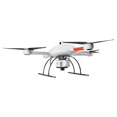
Microdrones - Model mdLiDAR3000 -LiDAR Drone System
Who Should Consider This System:
As you’ve come to expect, Microdrones provides you with the full solution: Plan, Fly, Process, Visualize. Only Bigger.
This is a serious machine for serious geomatics professionals in the construction, land development, engineering, surveying and research trades. It’s field tough and ready to work with you on the following tasks:
- Corridor mapping
- Mining (volume calculation)
- Construction site monitoring
- Environmental changes (time series)
- Forestry
- Contour mapping
- Leveling/Excavation
- Archaeology and cultural heritage
- Highway construction
The mdLiDAR3000 uses the lifting power, resilience and efficiency of the Microdrones aircraft platform to carry a perfectly integrated Riegl miniVUX‑1UAV (or an optional miniVUX‑1DL) and a Sony RX1R II camera. The result? You can quickly acquire high density and accurate LiDAR data in the field and efficiently turn it into a 3D colorized pointcloud back at the office or on your laptop.
mdLiDAR3000 is an end-to-end LiDAR solution combining a drone, a LiDAR payload, a fully integrated software workflow, and world class support to consistently provide quality deliverables.
Choose a perfectly integrated Riegl miniVUX‑1UAV or miniVUX‑1DL paired with a 42.4 megapixel camera mounted with a custom, lightweight, vibration-free, quick release mount to capture the data you need.
- Simple mission planning using mdCockpit
- User inputs the point density or flying height and drone speed
- Fully automated mission execution and realtime mission monitoring using mdCockpit
- Thorough georeferencing data processing using the dual-IMU Applanix APX-20 UAV DG and POSPac UAV DG
- Automated final point cloud processing using mdLiDAR processing software
- Final point cloud in standard ASPRS LAS format usable in any GIS or CAD software environment
- Quick and Accurate point cloud colorization using accurate system-produced orthomosaics and a user-friendly, seamless workflow