- Home
- Companies
- Microdrones GmbH
- Products
- mdTector - Model 1000CH4 - LiDAR Drone ...
mdTector - Model 1000CH4 -LiDAR Drone System
mdTector, from Microdrones, is a lineup of professional aerial inspection solutions. mdTector1000CH4, is a fully integrated aerial methane inspection package. It’s purpose-built for professionals who are responsible for inspecting methane gas infrastructure.
See and detect.
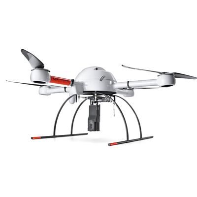
mdTector1000CH4 consists of a Pergam gas sensor, mounted and integrated perfectly with a Microdrones md4-1000 UAV. It has an onboard HD video link. That means that you can see in real time what you are detecting with the laser sensor.
It goes where people shouldn’t.
Whether your gas infrastructure is in a hard to reach riverbed or near a steep cliff… the tough, carbon-fiber built drone will easily navigate terrain that would be difficult, dirty or dangerous by traditional foot crews. Microdrones is known for its field-proven aircraft platform. It’s sturdy, stable, resistant to wind and weather, as well as dust and dampness.
A drone package for people who get stuff done.
The mdTector1000CH4 is versatile and can be used for:
- Natural Gas Line Surveys
- Tank Inspections
- Gas Well Testing
- Landfill Emission Monitoring
- Plant Safety
The mdCockpit Android App provides a live data view of potential gas leaks in real time during flight.
- Methane Column Density in ppm × m
- Sensor Status
- Plot the LMm readings
The mdTector Android App allows you to graphically visualize and present all exported post-flight data on one convenient map.
- Data includes LMM reading and GNSS position
- Import TFD from md4-1000
- Quickly export data to .csv for exploitation in GIS software
- Data is displayed by color
- Toggle between Google Imagery and Google Maps
mdTector1000CH4 is carefully integrated with a laser methane gas detection sensor and a visual camera so that the operator sees what the sensor is detecting.
View methane presence in real time during flight and create maps plotting methane levels detected, post flight.
mdTector1000CH4 is purpose built to withstand wind, rain, cold, heat, dust and dirt… and it easily flys above complex terrain, where foot-based teams are at risk of injury.
Carbon fiber construction combines strength with light weight. It’s easy to get to the field and to get jobs done efficiently.
- Low cost compared to the expense and risk of traditional gas detection methods
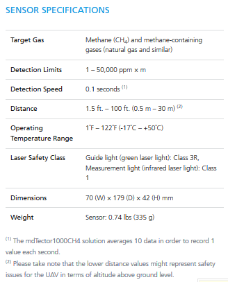
- Broad range of detection, from 1 – 50,000 ppm × m
- Lightweight and easy to transport
- Easy to deploy and operate
The mdTector Android App allows you to graphically visualize and present all exported post-flight data on one convenient map.
- Data includes LMM reading and GNSS position
- Import TFD from md4-1000
- Quickly export data to .csv for exploitation in GIS software
- Data is displayed by color
- Toggle between Google Imagery and Google Maps
- Low cost compared to the expense and risk of traditional gas detection methods
- Broad range of detection, from 1 – 50,000 ppm × m
- Lightweight and easy to transport
- Easy to deploy and operate
- The mdCockpit Android App provides a live data view of potential gas leaks in real time during flight.
- Methane Column Density in ppm × m
- Sensor Status
- Plot the LMm readings