
- Home
- Companies
- Phoenix LiDAR Systems
- Products
- Ranger - Model LR LITE - LiDAR System
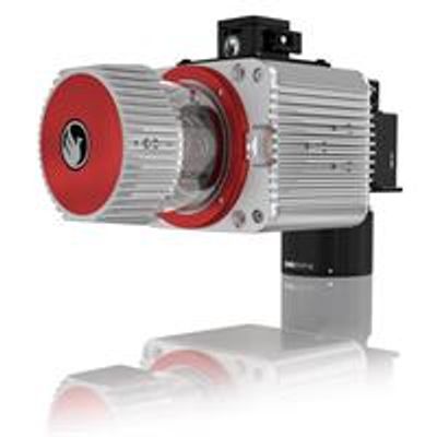
Ranger - Model LR LITE -LiDAR System
The RANGER-LR LITE is the new lighter Long Range system configuration of our RANGER Series. Designed for the most demanding mapping applications, the RANGER-LR LITE is the ultimate combination of high density, long range LiDAR with a powerful 1,550 nm laser that penetrates dense vegetation at high speeds and altitudes in large scan regions. This system is available in UAV, vehicle, VTOL and backpack configurations, depending on your needs.
FEATURING:
The New Phoenix LiDAR Systems AIR NavBox
The NEW RANGER LITE includes Phoenix LiDAR’s new AIR NavBox. The newest generation, ultra-lightweight (450g) rover will help meet the rigorous demands of various industries and applications by greatly increasing flexibility in two key areas: configuration of heavier payloads for the DJI M600 series; and higher range with the highest resolution cameras on the market.
The new Phoenix LiDAR AIR NavBox offers the most industry-altering capabilities in a tiny box not much bigger than a standard-size computer mouse.
58.5 x 123 x 48.1mm Dimensions (W x D x H)
450g Weight
Build the system you need to meet the growing demands of your clients in varying industries, from mining to agriculture and construction to forestry.
- Ideal for configuring heavier mapping payloads on the DJI M600
- Survey-Grade (cm-level) accuracy with 250m+ laser range and outstanding intensity calibration on high altitude and high speed missions
- Penetrates vegetation to produce accurate results
- Free basic online training included; PLUS complete Acquisition/Post-Processing/Pilot/Certification training also available (fees may apply)
- Free Phoenix Software Suite w/unlimited license; plus NovAtel & Terrasolid options also available (fee may apply)
- High accuracy due to precision Fiber Optic Gyro IMU
- Optional Upgrades: aerial systems, IMU and dual-GPS upgrade options for increased accuracy, integrated UHF radio modem, optional ground vehicle & UAV mounts/accessories, service plans and much more
- Live/Remote Data Feed: View and analyze data in real time or transmit live data to remote viewers via 4G connection
Primary Applications
- Vegetation Penetration
- Utility Infrastructure
- Open Pit Mining
- Forestry
- Construction Site Monitoring
- Cultural Preservation
- Glacier & Snowfield Mapping
- Land Erosion
Navigation System
- Integrated AIR NavBox
- Constellation Support: GPS, GLONASS, BEIDOU, GALILEO
- Support alignment: Kinematic, Dual-Antenna
- Operation Modes: Real-time, Post-processing optional
- Accuracy Position: 1cm + 1ppm RMS horizontal
- PP Attitude Heading RMS Error: 0.007° / 0.009°
Platform Specs
- Overall Dimensions, Sensor: 32.9 x 16.3 x 17.9cm
- Operating Voltage: 12-28 V
- Power Consumption: ~90 W
- Weight: 3.85kg / 8.5lbs (5kg w/ 100MP Camera)
- Operating Temperature: – 10˚ – 40˚ C
The RANGER LR-LITE is designed with flexible mounting options in mind. Maximize your investment by using the using RANGER on a UAV, vehicle, backpack or marine vessel. Ground vehicle options include Roof Rack or Suction Cup.
- 1550nm Laser Properties: Class 1 (eye safe)
- 25-35mm Absolute Accuracy: RMSE @ 150m Range
- 15mm Range Accuracy: One Sigma @ 150m
- 5m Range Min.
- 750k points Scan Rate
- 7x Returns/Echoes
- 360°h degrees Field of View
- 10-100 Hz Mirror Speed
- 0.001°mm Angle Measurement Resolution
- ∆ϑ: 0.06° ≤ ∆ϑ ≤ 1.5° Angular Resolution (Horizontal/Azimuth)
- 50/250/100050mmmm Laser Beam Footprint @ 100/500/1000m
- ∆ϑ 0.05° ≤ ∆ϑ ≤ 0.5° Angular Step Width (between consecutive laser shots)