
- Home
- Companies
- Phoenix LiDAR Systems
- Products
- Phoenix miniRANGER - LiDAR Systems
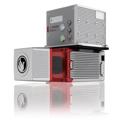
Phoenix miniRANGER - LiDAR Systems
This system features an impressive recommended AGL of up to 75 meters, filling a major AGL gap in the lightweight UAV LiDAR market. With the photogrammetry package, operators of mid-size multirotors, like the DJI M600 Pro, can now simultaneously acquire survey-grade LiDAR data and high resolution 42 MP RTK photogrammetry at up to 100 m operating flight altitude. Available in UAV, vehicle, and backpack configurations.
Build the system you need to meet the growing demands of your clients in varying industries, from mining to agriculture and construction to forestry.
- Survey-Grade (cm-level) accuracy with 250m+ laser range
- Outstanding intensity calibration on high altitude and high speed missions
- Penetrates vegetation to produce accurate results
- Free basic online training included; PLUS complete Acquisition/Post-Processing/Pilot/Certification training also available (fees may apply)
- Free Phoenix Software Suite w/unlimited license; plus NovAtel & Terrasolid options also available (fee may apply)
- High accuracy due to precision Fiber Optic Gyro IMU
- Optional Upgrades: aerial systems, IMU and dual-GPS upgrade options for increased accuracy, integrated UHF radio modem, optional ground vehicle & UAV mounts/accessories, service plans and much more
- Live/Remote Data Feed: View and analyze data in real time or transmit live data to remote viewers via 4G connection
Primary Applications
- Vegetation Penetration
- Utility Infrastructure
- Open Pit Mining
- Forestry
- Construction Site Monitoring
- Cultural Preservation
- Glacier & Snowfield Mapping
- Land Erosion
Navigation System
- Integrated Scout+ NavBox
- Constellation Support: GPS, GLONASS, BEIDOU, GALILEO
- Support alignment: Kinematic, Dual-Antenna
- Operation Modes: Real-time, Post-processing optional
- Accuracy Position: 1cm + 1ppm RMS horizontal
- PP Attitude Heading RMS Error: 0.009 / 0.019°
Platform Specs
- Overall Dimensions, Sensor: 26.9 x 9.9 x 8.5 cm
- Operating Voltage: 12-28 V
- Power Consumption: ~65 W
- Weight: 3.5kg / 7.7lbs. FOG IMU / 2.9kg / 6.4lbs STIM IMU
- Operating Temperature: – 10˚ – 40˚ C
Flexibility in sensing and mounting options is a key benefit of this Phoenix system. The miniRANGER is designed to fly on more robust UAVs, including the M600 Pro, and more. This system can also be adapted for vehicle configurations with Roof Rack or Suction Cups.
- 1 Laser
- 905nm Laser Properties: Class 1 (eye safe)
- 20-30mm Absolute Accuracy: RMSE @ 75m Range
- 15mm Range Accuracy: One Sigma @ 50m
- 3m Range Min.
- 100k points Scan Rate
- 5x Returns/Echoes
- 360°h degrees Field of View
- 10-100 Hz Mirror Speed
- 0.001°mm Angle Measurement Resolution
- ∆ϑ 0.05° ≤ ∆ϑ ≤ 0.5° Angular Resolution (Horizontal/Azimuth)
- 160mm x 50mm @ 100m Laser Beam Footprint
- ∆ϑ 0.05° ≤ ∆ϑ ≤ 0.5° Angular Step Width (between consecutive laser shots)