

- Home
- Companies
- Microdrones GmbH
- Products
- Microdrones - Model mdLiDAR1000 - Drone ...
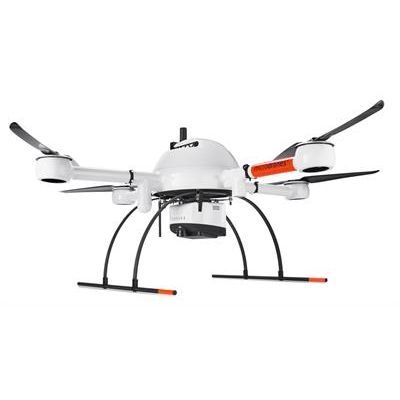
Microdrones - Model mdLiDAR1000 -Drone Based LiDAR System
This is the UAV, hardware, software, workflow, training and support that surveying professionals need.
Who Should Consider This System:
Professionals responsible for geospatial data collection should consider mdLiDAR1000 for the following tasks.
- Corridor mapping
- Mining (volume calculation)
- Construction site monitoring
- Environmental changes (time series)
- Forestry
- Contour mapping
- Leveling/Excavation
- Archaeology and cultural heritage
- Highway construction
LiDAR + Microdrones aircraft + easy to use software = extreme geospatial productivity
mdLiDAR1000 is a fully integrated system for producing 3D point clouds optimized for land surveying, construction, oil & gas, and mining applications.
mdLiDAR1000 consistently provides an accuracy of 6 cm (0.2 ft) when flown at 40 m (130 ft) at a speed of 3 m/s (6.7 mph).
Microdrones has developed an end-to-end LiDAR solution combining a drone, a LiDAR payload, a fully integrated software workflow, and world class support to consistently provide quality deliverables.
Easy end-to-end workflow:
- Simple mission planning using mdCockpit
- User inputs the point density or flying height and drone speed
- Fully automated mission execution and realtime mission monitoring using mdCockpit
- Thorough georeferencing data processing using the Applanix APX-15 UAV DG and POSPac UAV DG
- Automated final point cloud processing using mdLiDAR processing software
- Final point cloud in standard ASPRS LAS format usable in any GIS or CAD software environment