
- Home
- Companies
- Phoenix LiDAR Systems
- Products
- Pioneer - Model P10 - Long-Range Laser ...
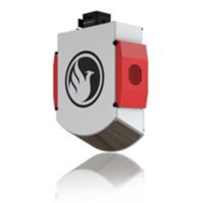
Pioneer - Model P10 -Long-Range Laser Sensor
The Pioneer P10`s long-range laser sensor highs only 3.8kgs and is a purpose-built, UAV LiDAR mapping system with a high-power 1550nm laser.
Most impressively, the Pioneer P10 allows users to finally fly at the maximum regulation AGL of 120m (400ft) and scan more area per flight due to its unique ability to focus all 640k points over a downward looking 110º field of view, making it the highest point resolution sensor of all commercial UAV LiDAR systems.
Scheduled for a US-release in late 2018.
Surveyors and LiDAR professionals can expect an increase of 300% in ground point density as compared to most other models at a comparable price point that spins the laser 360º, resulting in wasted data. Its 300m laser range also makes the Pioneer P10 ideal for achieving the best range and power for challenging scans such as high vegetation penetration above 100m with up to three returns.
Build the system you need to meet the growing demands of your clients in varying industries, from mining to agriculture and construction to forestry.
- High-power 1550nm single laser provides an unprecedented combination of range, resolution, intensity and accuracy
- Incredible ground point density due to focusing al laser pulses on the ground
- Compact, light-weight and rugged
- Free basic online training included; PLUS complete Acquisition/Post-Processing/Pilot/Certification training also available (fees may apply)
- Free Phoenix Software Suite w/unlimited license; plus NovAtel & Terrasolid options also available (fee may apply)
- Optional Upgrades: aerial systems, dual antenna GPS, IMU upgrade options, integrated UHF radio modem, optional ground vehicle & UAV mounts/accessories, service plans and much more
- Live/Remote Data Feed: View and analyze data in real time or transmit live data to remote viewers via 4G connection
Primary Applications
- Agriculture & Forestry Monitoring
- Railway Track Mapping
- Oil & Gas Surveying
- Utilities Mapping
- Open Pit Mining & Construtction
Navigation System
- Integrated NavBox
- Constellation Support: GPS, GLONASS
- Support alignment: Static, Kinematic, Dual-Antenna
- Operation Modes: Real-time, Post-processing optional
- Accuracy Position: 1cm + 1ppm RMS horizontal
- PP Attitude Heading RMS Error: 0.019 / 0.074°
Platform Specs
- Overall Dimensions, Sensor: 24.6 x 10.4 x 7.8 cm
- Operating Voltage: 12-24 V
- Power Consumption: ~60 W
- Preliminary Weight: 3.8 kg / 8.4 lbs.
- Operating Temperature: – 10˚ – 65˚ C
- 1550nm Laser Properties: Class 1 (eye safe)
- 20-30mm Absolute Accuracy: RMSE @ 75m Range
- 2m Range Min
- 640k points Scan Rate
- 2x Returns/Echoes
- 110° degrees Horizontal Field of View