Traditional LIDAR systems are designed to produce single wavelength backscatter measurement, however, this is not enough in many cases. Unlike other ceilometers, Raymetrics 3D Ceilometer is the only system to provide accurate three dimensional, scientific-grade precision measurements with a range up to 15Km

Raymetrics S.A.
- Home
- Companies
- Raymetrics S.A.
- Products
- Raymetrics - 3D Ceilometer
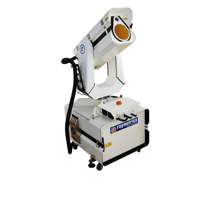
Raymetrics - 3D Ceilometer
FromRaymetrics S.A.
Truly Accurate Remote Detection Capability. Whether it is the critical information on the state of the atmosphere over the airport or the need to detect early incoming phenomena like fog, Raymetrics can supply you with the best remote sensing technology. Combining a decade of innovative development, providing products customized to various environmental conditions, Raymetrics 3D Ceilometer provides increased safety and efficiency of air operations.
Most popular related searches
runway visual range
remote sensing system
ceilometer
remote sensing
aviation meteorology
cloud thickness monitoring
LiDAR system
chemical analysis
atmospheric aerosol
LiDAR
Accurate three-dimensional cloud measurements.
Aviation | Meteorology
Remote Visibility
SVR, RVR, VOR (Vertical Optical Range)
Fog Detection
Incoming Fog Bank Detection
Fog cannot bypass as with in-situ sensors
3D Cloud Base
Remote Cloud Base – for forecasting
Total Cloud Cover – in 3D
Volcanic Ash
Definitive Volcanic Ash Identification
Altitudes of Ash Layers
Aerosol Monitoring
Partical Distinction
Planetary Boundary Layer (PBL)
Plumes
- Provides Slant Visual Range (SVR), a more accurate reflection of pilot’s visibility compared to Runway Visual Range
- Provides 3D cloud base (total ceiling), instead of cloud height at a single point like a regular ceilometer
- Remotely detects incoming fog banks, helping forecasters formulate early warning scenarios
- Provides detection of volcanic ash, natural dust and smoke, as an additional feature
Introducing the revolution in remote observation on the atmosphere (clouds, volcanic ash, etc), the Raymetrics 3D Ceilometer is designed to work as a visual radar, as well as to deliver records of the radiation that is backscattered in the components of the atmosphere (molecules, aerosols, clouds, etc.)
- Increasing airport traffic and functionality
- Reducing aircraft time spent in airport airspace
- Reducing travel time for passengers and goods
- Reducing landing and take-off run time
- Civil aviation authorities
- Airports
- Meteorological agencies
- Operates day and night, as it is based on its own radiation source
- Provides real-time results, since no sampling and time-consuming chemical analysis required
- Fully automated, remotely controlled 3D Data
- Unique technology in the sector