
- Home
- Companies
- Raymetrics S.A.
- Products
- Raymetrics - Model LR111-ESS-D200 - 3D ...
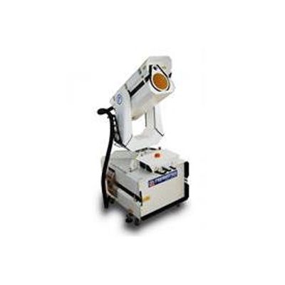
Raymetrics - Model LR111-ESS-D200 -3D Scanning Raman Depolarization Lidar System
Raymetrics` 3D scanning LIDAR is now available as a fully outdoor operational model designed for aviation, meteorology and environmental applications. ISO 9001:2015 certified.
The system comes with a large telescope and powerful laser, making it probably the most powerful eye-safe scanning aerosol LIDAR on the market, providing unparallelled data quality and effective range.
Detecting up to three wavelengths, including co-polar and cross-polar channels, the LR111-ESS-D200 is probably the only 3D scanning LIDAR powerful enough to detect nitrogen Raman at 387nm, allowing for more accurate data and better particle distinction.
Inbuilt climate control, UPS (for safe shutdown and automatic re-start on power loss), rain sensor and optional rain hood, make the system suitable for nearly all environments.
The LR111-ESS-D200 model aerosol LIDAR can be used for a variety of purposes, including remote visibility measurement (Slant Visual Range, Vertical Optical Range), 3D cloud base height, fog detection, pollution and dust tracking and many more.
Raymetrics’ 3D Scanning Aerosol LIDAR is an active laser remote sensing instrument designed to provide a variety of important information about the atmosphere. Aerosol LIDARs measure the particles, not of movement of particles as with wind Doppler LIDARs. This allows for applications including remote visibility (SVR, RVR, VOR), fog detection, remote cloud base height and more. With full 3D scanning capability, a powerful laser and a large telescope, Raymetrics’ LR111- ESS-D200 is probably the most powerful eye-safe 3D scanning LIDAR on the market.
Software provided for...
- Instrument Control
- Measurement Scheduling
- Alignment
- Set-up Procedure
- Data Acquisition
- Data Storage (Database)
- Advanced Analysis
- 3D Data Visualization
Note: Integration with software platforms available
The system emits an eye-safe laser beam into the atmosphere. Laser light is scattered by particles in the atmosphere and some is returned to a telescope. Because the speed of light is known, the distance to atmospheric layers can be determined. From the properties of the light ,certain atmospheric characteristics can also be determined.
- High energy laser emitting ~30 mJ per pulse at 355 nm
- Large 200 mm telescope designed specifically for LIDARs
- Range up to 10 - 15 km (with excellent Signal to Noise Ratio)
- Remotely controllable with full scanning capability
- Com plete software suite including real-time display and measurement scheduling
- Options available for nitrogen Raman at 387nm and Cross-Polarization at 355nm
- In-built industrial grade PC for easy networking
- Eye-safe according to EU standard on laser safety 60825-1: 2007
- Com plies with ISO 28902-1:2012 - visual ranging with LIDAR
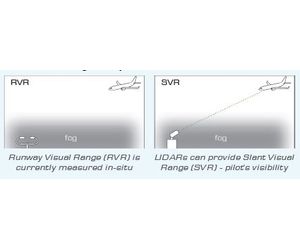
Remote Visibility
- SVR, RVR, VOR (Vertical Optical Range)
Fog Detection
- Incoming fog bank detection
- Fog cannot bypass as with in-situ sensors
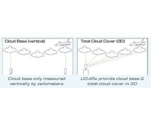
3D Cloud Base
- Remote cloud base - for forecasting
- Total cloud cover - in 3D
Volcanic Ash
- Definitive volcanic ash identification
- Altitudes of ash layers
Aerosol Monitoring
- Partical distinction (fire smoke, anthropogenic pollution, volcanic ash, dust, marine aerosols)
- Planetary Boundary Layer (PBL) - including mixing height, up and down drafts, aerosol loading
- Plumes

CASE 1: Measuring Visibility
- SVR gives a more accurate measure of pilot’s visibility
- ISO 28902-1:2012 means LIDAR is now a standard method of measuring visibility
CASE 2: Measuring Cloud
- Ceilometers use LIDAR technique - they are basic LIDARs
- LIDAR is therefore already the standard method for cloud base
- LIDARs offer increased power, range and capabilities
- EXPERIENCE: Raymetrics is probably the most experienced atmospheric LIDAR company in the world, (in operation since 2002).
- GLOBAL REACH: The company has installed instruments all over the world, including in Europe, North America, China, India, Africa, South East Asia and South America.
- EXCELLENT CLIENT BASE: Raymetrics’ client list includes such prestigious organizations as the European Space Agency, Meteo France, the German Aerospace Centre (DLR), the German Weather Service (DWD) and the Met Office (UK) ,which has a network of Raymetrics LIDARs installed specifically for volcanic ash detection. Raymetrics 3D Aerosol LIDARs have been used for meteorological and aviation applications including in Singapore (National Environment Agency), Chile (Dirección Meteorológica de Chile), France (Meteo France), Germany (SESAR project), Greece (Eleftherias Venizelos Airport) and Azerbaijan (Heydar Aliyev International Airport).
- REPUTATION: The company has an excellent reputation, particularly amongst the global LIDAR community.
- POWER: Raymetrics uses lasers with higher energy-per-pulse than other manufacturers, meaning greater range and better data quality. Note: LIDARs work by plotting every individual pulse - meaning energy per pulse is of the highest importance. Data quality can be improved by stacking multiple profiles together, but this does not greatly improve range.
- SIZE: Raymetrics uses larger telescopes than most other manufacturers in order to capture more signal.
- Note: Raymetrics telescopes are custom-designed with the focal point inside the telescope, allowing obscuration from the secondary mirror to be greatly reduced, resulting in up to 40% more signal.
- STANDARDS: Product com plies with ISO 28902-1:2012 - Ground based remote sensing of visual range with LIDAR. Com pany certified to ISO 9001:2008 standard.
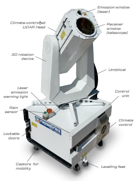
EMITTER
- Laser energy: 30mJ per pulse at 355nm
- Repetition rate: 20 Hz
- Beam Expansion: X10
- Eye-sate: YES (EU standard on laser safety EN 60825-1:2007)
- Laser Class: IV (within enclosure)
RECEIVER
- Size (primary mirror): 200 mm
- Field of view (FOV): 0.25 - 3 mrad (user adjustable)
- Overlap: < 200 m (wfth factory set FOV)
DETECTION UNTT
- Wavelengths detected: 355 nm co-polar
- Wavelength options (for particle distinction):355 nm cross-polar 387 nm nitrogen Raman
- Spatial resolution: 7.5 m
- Temporal resolution:
- 1 sec single shot
- 10 secs multiple acquisition mode (user selectable upwards)
- FWHM bandwidth: Approx. 0.5 nm per wavelength
- Detection modes: Analogue and photon counting for near and far field measurement
GENERAL
- 3D Scanning: 360° azimuth. 90° zenith
- Internal PC: Industrial grade PC running Windows
- Climate control: Heating and Air Conditioning units for both UDAR Head and Control Unit
- Software:
- Full suite of software supplied for
- Instrurnent Control
- Measurement Scheduling
- System Alignment and Set-up Procedure
- Data Acquisition
- Data Storage (Database)
- Data Analysis
- Data Visualization
- Automation: Remotely operable with measurement scheduing for automation]
- Warranty: 1 year as standard
- Training: 3 day installation and training course on site as standard
ADDITIONAL
- Effective Range: > 10 - 15 km*
- Envronmencal tolerance: -15 to +45 °C
- Dimensions: Approx. 18 m x IO m x 1.0 m (HxWxD)
- Weight: Approx. 220 kg
- Power:
- 110 - 240 V, 50 - 60 Hz (standard domestic power supply).
- Peak current 25 Amps.
* Effective renges depend on atmospheric conditions and i: ntegration times.
Description
- Raymetrics’ software team is developing firmware and software adding functionality to existing products in order to provide innovative solutions to its customers
- The new LiDAR firmware support efficient and remote control of LiDAR systems allowing it to be operated even in remote environments acting as early-warning systems for natural hazards like volcanic eruptions, wildfires and dust storms
- Α new, subscription based platform allows easy visualization and processing of data gathered by LiDAR systems, targeting both existing and new customers
- New processing capabilities will be available to subscribed customers Raymetrics is developing a unique cloud-based platform that integrates LiDAR data with other sensors and information sources to address specific clients needs
- An example of this platform is the new desert dust monitoring and forecasting solution, integrating state-of-the-art lidar processing algorithms and dust forecasting to a single web- based platform.
Software
- The new firmware optimizes system performance, eases maintenance of existing systems while speeding
- up the development cycle of new products
- The firmware is optimized for low connectivity installations, allowing the installation of system in remote
- areas such as early warning systems
- The new instruments are able to integrate with other internet-enabled devices, forming smart sensor
- networks and solving complicated client needs
- A subscription-based platform will allow customers to monitor the systems’ operational status, easing
- day-to-day operation and reducing unexpected failures
- At the same time, it will allow Raymetrics to promote pro-active maintenance contracts and suggest
- system upgrades based on the actual needs of each system ensuring a constant stream of recurring
- revenues
Firmware
- Raymetrics is developing new web-based platform that can handle data from both single lidar systems
- and large network.
- A subscription-based web-based platform for lidar data visualization and processing allow efficient
- management of lidar data, and easy integration to customer workflows.
- Innovative processing algorithms will allow to achieve user requirements with much lower hardware
- costs, significantly increasing the competitiveness of all Raymetrics products.
Software
Raymetrics provides a full suite of custom-designed LIDAR software in a common GUI with every system. No additional software is needed to run the system or perform advanced analysis. Modules are included for:
- System Alignment
- Measurement Scheduling
- Data Acquisition
- Data Storage (Database)
- Data Analysis
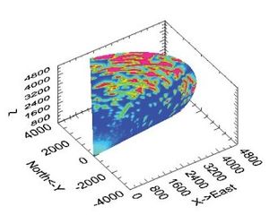
- Data Visualization (in 3D if system is 3D scanning)
- System Diagnostics
Automation
- Raymetrics LIDARs can be fully automated through measurement scheduling software, including 3D scanning systems which can be programmed with multiple scan patterns.
- Data can be displayed in real-time, with "quick-look plots" exported as jpegs either manually or automatically.
- Raymetrics` software now features auto-picking of atmospheric layers, including the Planetary Boundary Layer (PBL), clouds and aerosol layers.
- Software can also achieve automatic particle classification in real-time, allowing the user to discriminate between volcanic ash, dust, smoke and marine particles.
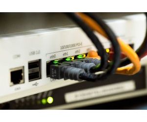
Networking
Raymetrics LIDARs are controlled by internal industrial grade PCs running Windows Operating Systems. As such, our LIDARs can be easily networked in all the myriad ways a PC can be networked. This can include connection via Ethernet to a network, with data sent to a remote server for distribution to web pages, or any other method. Raymetrics LIDARs can even be operated remotely from mobile phones or tablets.
Visualization
3D Scanning data can be displayed and viewed in 3D in Raymetrics` native software, or can be easily exported for use in other software (e.g. we can provide a simple 3-click solution for displaying data in Google Earth).
Data format
Data format is binary for fast processing, with the option to automatically convert to ASCII format for compatibility with other software.
Raymetrics does not currently limit the number of licences for users. Clients can even request access to the source code to develop additonal software modules, or can request Raymetrics to develop new modules.