
Remote Inspection Technologies (RIT)
- Home
- Companies
- Remote Inspection Technologies (RIT)
- Products
- RIT - Model HDS3000 - High Speed Laser ...
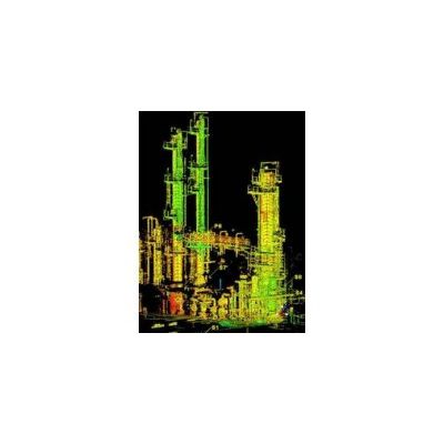
RIT - Model HDS3000 -High Speed Laser Scanner
Pulsed, high-speed laser scanner with survey-grade accuracy, range, and field-of-view. RIT provides High-Definition Scanning Services with terrestrial LIDAR scanners to produce accurate and robust 3D point-cloud models which can be used to create 3D CAD models.
Most popular related searches
laser scanning
asset management system
water treatment plant
LiDAR scanning
water treatment
safety data
asset management practice
water treatment system
prototype production
forensic
- Highly accurate and robust “as-built” data resulting in lower project costs
- Technology that is becoming accepted universally as the best practice asset management tool
- Rapid response and turn-around time
- Reliable, value-added support team
- Increased safety during data collection
- Industrial Large Scale: Tank farms, refineries, energy production, water treatment plants
- Commercial Building: As-builts, retrofits, floor plans
- Structures: Towers, bridges
- Architectural: Retrofits, remodels, zoning
- Consumer Products: Prototypes
- Virtual Reality: Digital models
- Heritage Preservation: Documentation and archiving of historical entities
- Forensic: Documentation and reconstruction
- Topographies: Surface configuration of an area, the features or configuration of a structural entity