

SatFish - Cloud Free SST Charts
Using the latest satellite and software technology, we can now see the surface temperature THROUGH the clouds. Use our Cloud Free Sea Surface Temperature maps to point you in the right direction even when Mother Nature isn’t letting us have a look at the true sea surface temperatures.
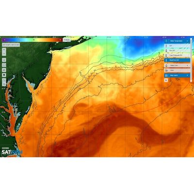
Satfish’s Cloud Free Sea Surface Temperature chart combines high-resolution sea surface temperature data blended with lower-resolution microwave SST data to produce the highest resolution cloud-free SST images available. As a result of the different technologies used to measure SST, Cloud-Free Sea Surface Temperature charts will usually appear much smoother than high-resolution Sea Surface Temperature charts especially when it’s cloudy. But when skies are clear, the high-resolution SST data will show through better and highlight more fine-scale breaks and eddies in the blended cloud-free SST image.
Cloud-free sea surface temperature images are produced daily for all of our regions and can be very helpful in helping locate warmer water currents that hold pelagic fish during periods of overcast and poor weather.
Your Membership Includes:
- Full access to all regions
- Detailed bathymetry maps
- Depth contours
- Fishing hot spots
- Fishing closures and political boundaries (where available)
- Custom detailed route planning
- FREE mobile app for iOS and Android devices
Sea Surface Temperatures:
- High-Res Sea Surface Temperature (SST) Charts (6-8 images/day)
- Cloud-Free SST (1 image/day)
- 3-Day Composite SST (1 image/day)
Water Color:
- High-res Chlorophyll Charts (2-3 images/day)
- 1-Day Composite Chlorophyll (1 image/day)
- 3-Day Composite Chlorophyll (1 image/day)
Imagery:
- ENHANCED True Color Satellite Imagery (1-3 images/day)
Satellite Altimetry:
- Sea Surface Height (1 image/day)
- Surface Currents Map (1 image/day)
Marine Weather:
- Real-time weather buoy data (updated every ~1 hour)
- 5-Day Wind Forecast (updated 4x/day)