

SatFish - Sea Surface Temperature (SST) Maps
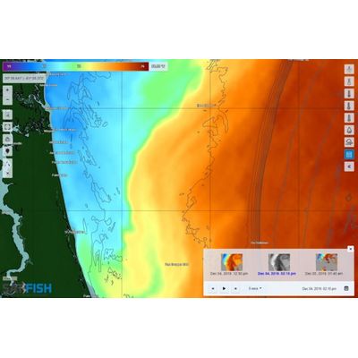
Sea surface temperature (SST) maps are made by satellites orbiting the Earth. These images show you where the water temps are right for the species you’re targeting, such as tuna, marlin, mahi, and wahoo. Temperature breaks also mark “edges” that congregate bait fish, kelp, weed lines and sea life.
SatFish processes data from multiple satellites, enabling us to provide you with multiple near real-time sea surface temperature maps every day. Our in-house expert with a PhD in marine science processes all the data for our fishing charts with our own custom filtering and analysis routines, delivering accurate SST images at the highest resolution possible as soon as possible after each satellite passes overhead.
The resolution and quality of a particular SST map depends on how close the satellite’s orbital track is to the region for which the images are generated. In clear-sky conditions, we can generate up to 8-12 SST images daily, giving you near-constant coverage around the clock. You can easily scroll through the latest week’s worth of images with thumbnail previews, allowing you to choose the best ones for the regions you’re targeting.
SST measurements can only be made in clear-sky conditions. SatFish’s advanced cloud-masking routines allow us to show the highest quality data with maximum coverage, making full use of all the clear data pixels. Even using our state-of-the-art cloud masking technology, at time clouds can make it impossible to generate high-resolution SST images. During extremely cloudy conditions, anglers can utilize our Cloud Free SST Images and SST Composites to get an overview of the conditions in the region.
Your Membership Includes:
- Full access to all regions
- Detailed bathymetry maps
- Depth contours
- Fishing hot spots
- Fishing closures and political boundaries (where available)
- Custom detailed route planning
- FREE mobile app for iOS and Android devices
Sea Surface Temperatures:
- High-Res Sea Surface Temperature (SST) Charts (6-8 images/day)
- Cloud-Free SST (1 image/day)
- 3-Day Composite SST (1 image/day)
Water Color:
- High-res Chlorophyll Charts (2-3 images/day)
- 1-Day Composite Chlorophyll (1 image/day)
- 3-Day Composite Chlorophyll (1 image/day)
Imagery:
- ENHANCED True Color Satellite Imagery (1-3 images/day)
Satellite Altimetry:
- Sea Surface Height (1 image/day)
- Surface Currents Map (1 image/day)
Marine Weather:
- Real-time weather buoy data (updated every ~1 hour)
- 5-Day Wind Forecast (updated 4x/day)