

- Home
- Companies
- Sensors & Software - an SPX Corporation ...
- Products
- Sensors & Software - Model LMX200 - ...


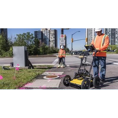
Sensors & Software - Model LMX200 -Ground Penetrating Radar (GPR) Locating Tool
GPR is widely used for Utility location and is used for identifying and marking utility mains that are underground. Typical underground utilities include lines for natural gas, cable television, fiber optics, telecommunication, electricity distribution, traffic lights, street lights, etc.
LMX200™ is the Premier Ground Penetrating Radar (GPR) Utility Locating Equipment in the market today.
The LMX200™ provides unprecedented insights and target confidence to detect traditionally non-locatable subsurface features such as:
- Non-metallic pipes, including PVC and asbestos cement
- Underground Electrical Cable
- Concrete storm and sewer systems
- Utilities where installed tracer wiring has failed
- Underground storage tanks and drainage tiles
- Septic system components
- Non-utility structures such as vaults, foundation walls and concrete pads
Public utility systems and local governments require that the positions of underground systems are located and marked. This helps in planning projects and avoiding risks and hazards. The LMX200™ builds on the capabilities of the LMX100™ and adds further features to help you locate and map these utilities. It adds the powerful Grid Scan mode and the ability to use an external GPS to take full advantage of SplitView and MapView. The LMX200™ also allows data export for post-processing, archiving, reference and further mapping capabilities in EKKO_Project™
Powerful touch screen display unit with enhanced on-site capabilities:
- Line Scan Mode with SplitView* (*External GPS required)
- Grid Scan
- MapView
- Wi-Fi On-site Mini-Reports
Lightweight fiberglass cart frame
- No metal parts that would interfere with GPR signals
Lead acid gel cell battery
- Long lasting
- Swappable
GPR Sensor
- Patented ultra-wideband (UWB) 250 MHz GPR antenna
- DynaT™ for Dynamic Target enhancement
USB for data transfer
- Further post processing in EKKO_Project™ ** (**Optional EKKO_Project™ GPR data analysis software)
- Data referencing and archiving
Optional External GPS
- Higher accuracy geo-referencing of targets for post processing in CAD and GIS software
- Enables SplitView and higher accuracy MapView images
For more information about LMX200™ features, click here and for pricing, please contact us.