

- Home
- Companies
- SENSYS GmbH
- Products
- SENSYS - Model MagDrone R4 - ...
SENSYS - Model MagDrone R4 -Drone-Integrated Magnetometer for High-Resolution Surveys
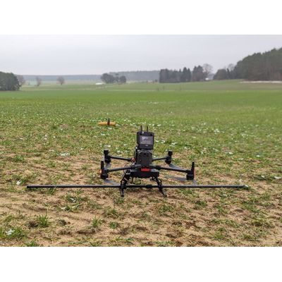
The MagDrone R4 by SENSYS is an advanced drone-compatible magnetometer designed for high-resolution mapping and surveying over extensive areas where traditional ground surveys are impractical. Unlike its predecessor, the R3, the R4 excels in detecting small, compact objects and underground structures, ideal for identifying unexploded ordnance, archaeological features, and past settlements. Operating at a sensor distance of 50 cm with a track spacing of 2.5 meters, it can cover between 3 to 4 hectares per hour. It offers straightforward operation with a single button interface and an onboard server accessible via Wi-Fi-enabled devices such as smartphones and tablets. Data processing is facilitated by the MagDrone Data Tool, which enables track identification, data filtering, and exportation for use in MAGNETO® software or other applications. Furthermore, its 200 Hz sampling rate ensures effective noise filtration from surrounding infrastructures and UAV motor emissions, consolidating its integration onto drone landing gear.
The MagDroneR4 is an ultra-portable magnetometer survey kit with five 3-axis sensors that can be attached to any drone (UAV) with a payload of >1500g.
MagDroneR4 - High resolution mapping
MagDroneR4 is an ultra portable magnetometer survey kit. It is made for large area surveys whenever ground surveys by man or vehicle are not possible anymore. (UAV)
In opposite to the R3, the MagDroneR4 is used for high resolution mapping in order to detect small and compact objects as well as structures in the ground, such as bombs, ammunition or settlement features from the past. A sensor distance of 50 cm at a track distance of 2.5 m allows an area output of 3 to 4 ha per hour. Other solutions are available on request!
Operating the MagDroneR4 is as simple as with the R3, again. It only comes with one button and an onboard server to be accessed from any WIFI device, such as smartphones, tablets or laptops. That helps for any easy setup, configuration, system check, as well as remote start/stop of recordings and data download. The MagDrone Data Tool helps to identify flown tracks, cut, filter and compensate the raw data, generates a preview and exports into various formats to further process the recorded values i.e. using the MAGNETO® software, GIS tools or Matlab with your own scripting.
MagDrone series - Filter out noise
With 200Hz sampling rate the MagDrone series can easily filter out noise from net frequencies, infrastructure or the UAV / Drone motors. Hence, the MagDrone devices can be directly installed on the drone landing gear to enable a very compact setup.
The applications
The MagDroneR4 survey kit can be used for general purpose surveys, science related magnetic cartographies, mine exploration, as well as for safety relevant operations such as area scanning for bombs and ammunition, preventive check and surveillance of areas and camps against intrusion.
MagBase - Magnetometer data
Together with the SENSYS tool MagBase acting as a reference station, the drone based magnetometer data can be correlated with those from the MagBase. That will enable the cancellation of temporary noise sources such as crossing vehicles or net frequencies.
Technical Data MagDrone R4 :
General Technical Data :
- Power Supply : 18 V; 1,500 mAh Li-Ion re-chargeable battery
- Operating Temperature : -20°C to +50°C
- Weight / with Li-Ion battery : 2700 g / 3000 g
- Overall power consumption : 10 W
FGM3D/75 Fluxgate :
- Number and orientation of sensors : 5 pieces, laid horizontal, parallel
- Specified measurement range : ±75,000 nT (higher ranges available on request)
- Number of sensor axis : 3
- Distance between sensor centre points : 250/500 mm
Datalogger :
- Sensor input : Internal wired
- User Interface : Start/Stop button; Web Interface
- Survey mode : Recording when start/stop pressed
- Sampling rate : 200 Hz (higher rates available on request)
- Internal memory : 8 GB
Standard package :
- MagDrone R4 : Sensor frame, 5 pcs. built-in FGM3D/75 sensors, data logger (fixed to tube), 2 pcs. rechargeable batteries
- Rugged case (W x D x H) : 820 x 530 x 300 mm
- GNSS : External GPS input
- Peripherals : charger, case, USB memory stick with software
- Documentation : Certificate, manual
- PC software : MagDrone DataTool
Optional accessories :
- Data processing : MAGNETO® Software