

- Home
- Companies
- Wildlife Computers
- Products
- Wildlife Computers - Model microPAT-401 ...
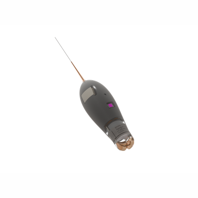
Wildlife Computers - Model microPAT-401 -Smallest Geolocating Satellite Pop-Up Tag
The microPAT is the smallest geolocating satellite pop-up tag on the market. The microPAT is used to track the behavior and migration of marine animals. The microPAT has archiving capabilities, a corrodible attachment link, and functions as an Argos transmitter. Throughout deployment, the microPAT collects depth, wet/dry, temperature, and light-level data, which are archived in the onboard memory. Then, on a preset date or duration determined by the researcher, the tag releases from the animal and floats to the surface. The archived data are then summarized and uploaded via the Argos satellites. Engineered with a keen focus on reliability, ruggedness, and user-friendly operation, the microPAT boasts a stable, low-drag shape and a robust urethane nose.
- Empirical Cumulative Distribution (ECD)—ECD of depths including the minimum and maximum depths encountered, as well as the depths above which (i.e., shallower than) the animal spends 25%, 50%, and 75% of its time during fixed 6-hour summary periods. For each ECD depth, the tag also provides the maximum temperature encountered during the summary period, providing a temperature profile of the water column. These are behaviorally driven temperature profiles. Note: Due to limited bandwidth, the tag will attempt to send three out of four 6-hour summary periods per day at random.
- Time-Series—limited depth and temperature time series provides low frequency reporting of sensor data for instruments which may never be recovered. Each depth and temperature time series message contains time series data sampled at a fixed 600 seconds for the end and/or beginning of the deployment, depending upon the deployment duration.
- Locations—after the microPAT releases from the animal, it generates Argos locations that, along with light and surface data, are GPE3 compatible.
- Archive—depth, temperature, wet/dry, and light-level readings are stored. When a microPAT is recovered, the full archive is available for download.
- The smallest pop-up tag available for tracking movements of small epipelagic fish for deployment durations up to one
year. - GPE3 compatible—uses known locations, light, sea-surface temperature (SST), bathymetric, and land-avoidance
observations to estimate locations. - Uses proven technologies based on the MiniPAT for recording and transmission of position, depth, and temperature
data.
Auto-Detect Mortality and Tag Detachment—the microPAT monitors for constant depth, indicating that the tag is resting on the sea floor, and constant dryness, indicating that the tag is floating at the surface. If either of these conditions is met, the microPAT will release. This feature ensures that the microPAT will transmit even in the event of attachment failure or animal mortality, minimizing the chance of damage to the tag between the conditional release event and the programmed pop-up date.
Adaptive Transmission Schedule— the microPAT’s message creation and transmission schedule is adaptive. Intelligent and responsive software waits until after release to package data messages for transmission. This approach enables the tag to send as much data as possible, considering the release date, and aids in determining the cause of conditional release events.
The Portal Advantage—microPAT tags are supported by the Wildlife Computers Data Portal, which comprises a collection of data management tools and services. Specifically designed for displaying and investigating data from Wildlife Computers tags, the portal streamlines processes related to data acquisition, preservation, and sharing services. This is the platform where you can access, prepare, and analyze data returned from tags—via Argos or the archive. Data can be easily sorted, filtered, searched, uploaded, and shared. You have the capability to view a Google Earth display of the tag’s trajectory, color-coded to indicate the relative age of each location. Additionally, you can overlay other live Argos tracks via LiveMaps, embed the map(s) into a website, and set up a live KMZ to integrate data into your own monitoring system.