

XAG Co., Ltd.
- Home
- Companies
- XAG Co., Ltd.
- Products
- XAG - Model M2000 - Remote Sensing ...
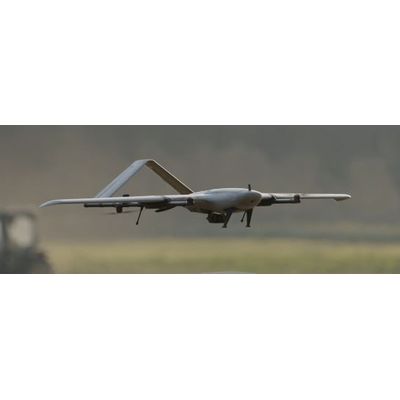
XAG - Model M2000 -Remote Sensing Drone
FromXAG Co., Ltd.
With the fixed-wing VTOL design, XAG M2000 Remote Sensing Drone is developed for high frequency and high demand aerial survey tasks of multiple scenarios, which allows one person to map fields of 533 hectares in an hour¹. Equipped with XAG SuperX 4 Pro Intelligent Control System, the XAG M2000 is capable of accessing quality geographic data, which helps build up digital field maps stably and rapidly to facilitate production decisions.
Most popular related searches
Accurate & Autonomous Flight
- RTK Centimetre-Level Positioning
- Automated Flight Planning
Flexible Take-off and Landing
- Fixed-Wing VTOL Design
- Quick Release Body
Sophisticated & Stable Imaging
- XCam 20MP Pro Gimbal Camera
- XCam 26MP APS-C Gimbal Camera
- XCam 20H Hybrid Gimbal Camera
- XCam 20M Multispectral Gimbal Camera
Safe & Efficient Images Stitching
- Cluster Cloud Computing with Encryption
- Post Processed Kinematic