

- Home
- Companies
- YellowScan
- Products
- YellowScan Navigator - Bathymetric ...
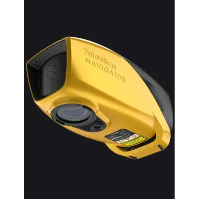
YellowScan Navigator - Bathymetric LiDAR System for Aerial Surveys
The YellowScan Bathymetric LiDAR system is designed for aerial deployment on UAVs, providing in-depth analysis of underwater and land topography through a streamlined, single-button operation. This system employs a class 3B laser scanner developed in-house, optimized for seamless underwater data collection, ideal for topographic continuity in various terrains. Its compact design ensures compatibility with a wide range of UAV platforms, and it includes advanced software features for data processing. The LiDAR system supports applications like coastal mapping, underwater archaeology, and hydrology studies, utilizing a green laser to maximize depth penetration while maintaining safety protocols. Essential components such as high-density laser goggles and a GNSS antenna enhance operational capability. The system integrates with YellowScan's CloudStation software to automate water classification for precise mapping, ensuring data accuracy via underwater point correction and a built-in global shutter camera for imagery fusion.
The YellowScan bathymetric LiDAR is an innovative solution for exploring underwater and ground topography with a single-button operation. Its lightweight design allows for versatile platform selection without compromising water penetration.
- Technology inside : YellowScan laser scanner
- IMU solution : SBG Quanta Micro
Simultaneous land & water survey
The YellowScan Bathymetric system is designed for conducting bathymetric measurements in shallow waters and is rapidly deployable on a UAV. This full waveform LiDAR system ensures continuity between underwater points and the surrounding terrain.
Diverse water environments
Intended for aerial use on drones, the system covers various water areas such as shorelines, rivers, lakes, estuaries, ponds and gravel pits. Navigator is user-friendly and adaptable for a wide range of applications, from hydrographic surveys to underwater resource management.
40° FOV for high precision
Our bathymetric system, with a 40-degree field of view, prioritizes precision over a broader angle. This decision is based on the fact that 40° is the maximum angle for a green laser to perform effectively underwater. Beyond this angle, the laser’s penetration depth in water is significantly affected, limiting the system’s overall performance.
High autonomy for maximized efficiency
Optimize your bathymetric survey operations with our LiDAR system, delivering a 45-minute autonomy on a single battery charge for extended underwater data collection in various marine settings.
Embedded camera
The Navigator features an embedded camera (global shutter) that can be used for colorization purposes.
A YellowScan development
This solution features a laser scanner developed in-house by our R&D team over the last few years with tests that kicked off in 2023, refining the system for optimal performance. This evolution highlights our commitment to innovation and quality, particularly in the development of advanced laser scanners.
- AGL Altitude : Up to 100m 330ft
- System precision : 3cm 1.2"
- System accuracy : 3cm 1.2"
- Battery weight excl. : 3.7kg 8.2lbs
- Precision : 3 cm (1.2")
- Accuracy : 3 cm (1.2")
- Max. water depth : 2 Secchi
- Typ. flight speed : 5 m/s
- Max. AGL altitude : 100 m
- Laser range : Up to 120 m
- Laser scanner : YellowScan development
- GNSS-Inertial solution : SBG Quanta Micro
- Scanner field-of-view : 40°
- Integrated camera : Built-in global shutter
- Echoes per shot : Up to 10
- Shots per second : Up to 20 000
- Scanning frequency : Up to 50 Hz
- Weight : 3.7 kg (8.2 lbs) battery excl.
- Size : L 350 x W 160 x H 190 mm
- Autonomy : 45 min. typ.
- Power consumption : 120 W
- Operating temperature : 0° to +40 °C
- Nominal ocular hazard distance : 25 m
- Laser class : Class 3B