
- Home
- Companies
- Park Seismic LLC
- Services
- Active and Passive MASW Surveys in 1-D, ...
Active and Passive MASW Surveys in 1-D, 2-D, and 3-D Formats Services
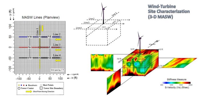
Active surveys are performed by using an actively controlled seismic source such as a sledgehammer and an acquisition system consisting of a linear receiver array usually of 24-channels (or more). This type of survey is the most common and can usually achieve an investigation depth of 100 ft or less. Results can be 1-D, 2-D, or 3-D maps showing subsurface distribution of ground stiffness (quantitatively shear-wave velocity, Vs). These maps can show bedrock depth and topography, location of weak zones (e.g., sink-hole hazard or fracture zones), buried boundaries (e.g., landfill, reclaimed zones), and soil characterization, among many other applications.
Passive surveys can achieve investigation depth of several times deeper (e.g., 300 ft), with the field deployment several times bigger as well, than the usual active surveys. The passive remote survey can give a shear-wave velocity profile in 1-D format, whereas the passive roadside survey provides a shear-wave velocity profile in 2-D format.
An area of moderate size (e.g., 200 m x 200 m) can be surveyed in one or two days for an active 2-D survey, and draft results can be obtained within an additional day. The entire project until the final report is available usually takes one week or so. An active 3-D project usually takes a few times (e.g., three times) longer than a 2-D project.
For suitability and feasibility for your project, contact us. We will provide a free consultation and sometimes run modeling experiments to predict the chance of success and possible limitations of your project.
You do the field work, we process and submit a report back to you! If seismic data acquisition equipment is available locally-many local service companies own it or can rent it from other companies-we can provide the necessary information about field procedure to acquire data according to preset field logistics. Once you send us the data set you collected online, we will do the rest: processing, interpretation, and reporting. This option provides a great advantage by saving overall project cost and obtaining the necessary information in the fastest way. In most cases, a 2-D project can be processed overnight and draft map can be delivered next morning. We recommend this option, however, only if you have some experience in geophysical (preferably seismic) field surveys.
We provide tutorial service in field-operation and/or data-processing of the MASW method. This can take place synchronously as we perform one of your projects in field and classroom, covering basics on the method itself including field strategies, data processing, and interpretation. We can customize the tutorial according to the level of your experience or special focus of your interest.