- Home
- Companies
- Geotec Engineering & Environmental ...
- Services
- Borehole scanning
Borehole scanning
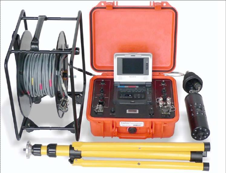
Explorer 2000 is a unique photography system that enables to locate, map, examine, scan and measure boreholes and voids. This is a digital video recording system combined with a laser range finder, developed specifically for inspecting the bottom and sidewalls of boreholes, and assessing the volume of subsurface cavities. It is ideal for all applications requiring high resolution color photography of the borehole and its sidewalls.
The photography system is used for scanning boreholes of different diameters; it can also be used as a bore-scope for inspecting very narrow boreholes and fissures. The cameras enable 360° photography of the sidewalls and the bottom. Explorer 2000 is an extremely robust system, suitable for extreme working conditions – depths of up to 90 meters, with water impermeability to a depth of up to 10 meters. To achieve the highest level of accuracy, the borehole photography system can be used in conjunction with the ground penetrating radar. Explorer 2000 was developed by Tamar Advanced Quarrying Technology Ltd., and is periodically upgraded by Geotec.
- The Explorer 2000 system
- Geotec, in cooperation with the Israeli company, Scan In, is currently developing a new photography system, which will integrate new, advanced technologies
- Civil engineering: inspecting boreholes at quarrying, excavation and construction sites
- Geology and geotechnics: alternating layers, fissure areas, caves and voids
- Safety and security: assistance in saving and extracting from pits, wells and caves
- Archeology: use of photography equipment to photograph and map caves