

Floodplain Analysis, Mapping, and Management Services
Rivers and their associated floodplains serve a variety of important natural functions including conveying water and sediment, storing flood waters, and providing diverse habitat. Floodplains, however, are also prime areas for agriculture and commercial and residential development that may be prone to flood damage. Floodplain analysis and management seeks a balance between conserving natural functions and reducing flood risks.
NHC investigates and analyzes floodplains ranging in size from small urban streams to the world`s largest rivers, and in geomorphic settings from alluvial fans to major river deltas. We participate in small-scale restoration projects and conduct flood risk assessments and mapping for major rivers. Regardless of project scale or setting, we emphasize the need for sufficient basic data, a thorough understanding of the hydraulics and morphology of rivers and floodplains, and close attention to the objectives of the project and the client.
NHC conducts studies for a broad range of floodplain applications, including:
Flow Prediction
Hydrologic analyses and numerical modeling of watersheds to determine key river flows.
Hydraulic Modeling of Flows
Numerical hydraulic modeling of complex within-channel and overbank flow scenarios.
Flood Assessment
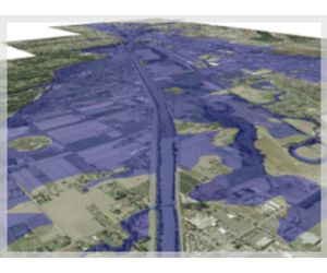
Flood risk assessment and mapping of flooded areas for specified return periods (e.g., 100-year flood).
Flood Protection
Planning and design of flood protection such as dikes and levees.
Aquatic and Riparian Habitat Restoration
Designing habitat restoration to reestablish or enhance natural functions.
Impact of Landscape Changes
Geomorphic assessments of natural and man-made changes to the channel regime.
Sedimentation Effects
Analyzing and managing sedimentation and resulting effects on flooding and infrastructure.
NHC has conducted many floodplain studies for government agencies and private clients in North America and internationally. Examples include:
Flood Hazard Reduction
Studies to understand complex flood behavior and reduce flood hazards. These studies often incorporate sophisticated numerical modeling tools, GIS, and innovative statistical approaches.
Habitat Restoration
Integrating knowledge of physical processes, engineering knowledge, and economic challenges to restore natural function to rivers and floodplains.
Regulatory Compliance
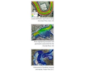
Permit applications to comply with local, state, and federal flood regulations including levee certification, shoreline mapping, and analysis and mapping of pre- and post-project conditions.
Risk Assessment and Mapping
Flood hazard assessments within the floodplains for many projects, including dam failure analyses. Information is provided to clients and the public in clear, detailed, and educational maps.
- Better understanding of flood risks allows public agencies and developers to plan for better and more certain community safety.
- Habitat diversity can be maintained or restored.
- Reduces flood risks to life and infrastructure.
- Allows communities to coexist with the natural environment.