Technology Experts Co.
GIS Department
Technology experts provides technical consultancy in area of (GIS) and technical advice to a number of professional customers through specialists and experts in the fields of geographic information systems, informatics and remote sensing.Most popular related searches
geographic information system
satellite image
geographic information
remote sensing
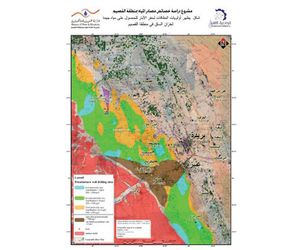
geological mapping
water quality
water resource
environmental impact
water supply
remote sensing service
Some services provided include:
- Processing and interpretation of satellite images and aerial photographs (remote sensing).
- Conversion of coordinates (levels and projections and Spheroids).
- Determine the suitable methods and techniques of GIS to solve spatial problems.
- Data collection, compilation and verification in the field (attribute and place and time).
- Development and design of different spatial databases.
- Creation of different spatial maps using satellite images, topographic maps, geological maps and structural maps.
- Create maps showing the results of GIS spatial modeling.
- Administration fastest and most effective irrigation and farm management through geographic information systems.
- GIS applications in the field of environment (spatial analysis) to assess the environmental impact.
- Site analysis to determine the optimal locations for the landfill.
- The application of GIS in the field of water resources, wells distribution and water quality depending on the location.
- The application of GIS in water supplies and sanitation.