

- Home
- Companies
- INTERA Incorporated
- Services
- Statistical & Geostatistical ...
Statistical & Geostatistical Forecasting Services
INTERA has over 20 years of experience in the development and application of statistical and geostatistical tools to hydrologic and hydrogeologic data. Our personnel have developed statistical models for time series data such as rainfall and ET, groundwater and surface water data, wetland and lake-level data, water quality, and short term and long term water demand.
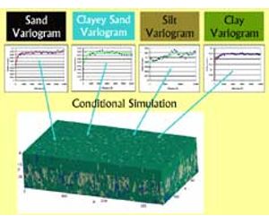
INTERA`s geostatistical experience ranges from applying indicator kriging to develop facies or stratigraphic models to conditional simulations of aquifer properties for use in Monte Carlo simulations. Much of our recent experience has focused on applying statistical and/or geostatistical models in support of water resource management plans. We have used geostatistics software such as GSLIB and ISATIS as well as the geostatistical packages available within the GMS and ESRI ArcGIS (i.e., Geostatistical Analyst) software packages.
INTERA is a leader in applying artificial neural networks (ANNs) to hydrologic systems. ANNs fall in the class of universal approximators and have been shown to be powerful statistical tools in quantifying the cause-and-effect relationships between different hydrologic variables. ANNs are extremely useful for modeling data such as brackish water encroachment or surface water level impacts due to wellfield pumpage or to predict water levels within a highly responsive surficial aquifer.
Exploratory Data Analysis
- data acquisition & database construction
- spatial and temporal trend analysis
- statistical model selection based on project objectives, conceptual model, budget and schedule
Statistical modeling of hydrologic data
- data reconstruction (filling data gaps)
- time series analysis
- principle component analysis
- explanatory statistical model development
- artificial neural network model development
Geostatistical Analysis
- cluster analysis
- trend removal
- structural analysis variogram modeling
- linear geostatistics - kriging
- nonlinear geostatistics Indicator kriging
- simulation Gaussian and non-Gaussian