
- Home
- Companies
- GEL Engineering LLC
- Services
- Subsurface Utility Engineering
Subsurface Utility Engineering
GEL Geophysics is proud of our track record in providing challenging Subsurface Utility Engineering (SUE) solutions. We help our clients avoid service interruptions, project delays and possible catastrophe due to unexpected encounters with buried utilities and other infrastructure. Our goal is simple: solve complex underground mapping issues with precise and timely answers.
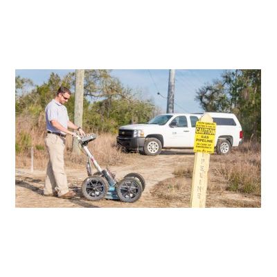
Computer Assisted Radar Tomography (CART) for the Best Underground Images without Excavation
We use Computer Assisted Radar Tomography (CART) imaging technology as a non-invasive way to produce the best pictures during subsurface investigations: a single pass over a 6.5-foot wide area generates 100% coverage in a fraction of the time it takes using conventional GPR systems. As opposed to single-channel GPR systems that provide only 2-dimensional images, CART is an innovative, 16-channel GPR imaging system that provides accurate, detailed 3-D images of underground features. A robotic total station also continuously tracks the CART system’s precise horizontal position, recording during data collection. So there is no need to survey utility marks after the fact.
Benefits and Applications
Whether for archaeology excavations or to identify utilities, our CART technology can:
- Detect metallic materials and non-metallic utilities such as plastics/PVC, fiberglass, concrete, vitreous clay, etc.
- Identify cracks, voids, and buried assets in road surfaces
- Provide accurate depth estimates of utilities
Ground Penetrating Radar (GPR) to Detect metallic and non-metallic
Ground Penetrating Radar (GPR) helps our team detect interface between materials with differing electric properties. Low frequency unshielded GPR antennas allow us to penetrate deep into the subsurface while maintaining relatively high resolution data. Borehole radar is a distinctive, being the only tool which can investigate subsurface conditions beyond the borehole wall, as well as fractures and voids that do not intersect the borehole wall.
Benefits and Applications
GPR is able to detect both metallic and non-metallic objects. We use GPR for:
- Underground utility designation and mapping
- Underground storage tanks (UST) and buried drums
- Archaeology/cemetery
- Geology
- Delineating landfills and buried debris
- Concrete rebar mapping
- Forensics
- Voids
- Foundations
The GPR instrument produces a continuous cross section of subsurface reflections, so operators can see the results on-the-fly or download the data to a laptop for more thorough analysis.
Vacuum Excavation Services for Visual Inspection
When the exact location of a buried asset is required, vacuum excavation is a fast, safe, cost-effective, and non-destructive means of accomplishing the task. Vacuum excavation, also known as "potholing" or "soft digging," not only provides an exact location and depth, but also allows for visual inspection of the utility.
Benefits and Applications
Vacuum excavation eliminates the uncertainty of damage associated with mechanical excavation and the time delays of hand-digging. It creates one-foot or less diameter holes, making the technique also useful for:
- Pre-boring (clear holes) in congested environments
- Establishing pilot holes for posts and utility poles
Subsurface Utility Engineering Data Delivered the Way You Need It
We customize reports to your needs. Following data collection and processing, we seamlessly integrate all target features such as utilities into AutoCAD, MicroStation, or GIS deliverables — whatever format you prefer. After all, the true value of any technology is its ability to simplify the complex and make the data usable for all stakeholders in a project.