
Surface Water
Our services include, but are not limited to:
Flood modelling, flood hazard maps and correction measures:
Our models are calibrated against existing data sets (e.g., flood or high water episodes). Once the reliability of the model is validated, the model can be used to forecast high water scenarios corresponding to different return periods (e.g., HQ100, HQ300, HQ550). These forecasts are the basis for our design of correction measures to prevent from flood events.
Regulated conditions at hydraulic power stations, weirs and gates:
The versatility of our toolbox allows us to accomodate regulated conditions (i.e., water elevation or flux depending on what occurs elsewhere) at singular elements like weirs, dams or gates.
Model generation and calibration:
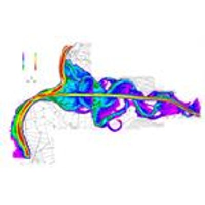
Discretization of river networks is not an easy task. Our software package Mesh_Rivers makes use of cross sections and a Digital Elevation Model (DEM) to define the topography of the river talweg. The horizontal definition of the river is made by user base lines depicting the river axis and margins. As such, rivers ressemble natural shapes, including U-turns over small distances. Our toolboxes can accomodate the existing (or planned) buildings as no flow conditions easily. In addition, high resolution data like ALS can be easily accomodated to enhance model accuracy. This confers a high versatility to our river network models.
Sediment transport and wood debris:
The potential damaging effects of sediment transport and wood debris under high water conditions is large. Even under natural conditions, sedimentation and erosion processes may change the morphology of the river bed or damage structures like bridges. Our toolbox allows us to account for these effects.
Lakes:
Hydraulic and sediment transport models can be applied at lakes as well. Most often, the output of these models becomes an input for further modelling of river networks or flood episodes.