- Home
- Companies
- Technology Experts Co.
- Services
- Well Logging & Geophysical Survey Dept
Well Logging & Geophysical Survey Dept
Technology Experts Company has undertaken massive groundwater assessment, monitoring, natural radiation measurement and mitigation. One of the main frameworks of the groundwater and underlying strata assessment is the geophysical well logging field acquisition- with ten borehole sondes measuring over thirty parameters, including the visual inspection of boreholes. The Well Logging department also provides necessary training for new geologists and engineers in the field of geophysical acquisition and data interpretation.
Members
- The borehole geophysical field acquisition team of Technology Experts Company is composed of the following personnel:
- John Kenneth B. Santos – Geologist/ Radiation Protection Officer
- Edmond John Pangilinan – Geologist
- Ali Bakri – Geophysicist
- Omar Al Bagadi – Geologist Assistant
Geophysical Well Logging:
Over the years, the Well Logging Division had caried out over two hundred well logging projects, most of them submitted to the Saudi Ministry of Water and Electricity. Various Saudi drilling companies hire Technology Experts’ more cost-effective, optimum output reports with full geophysical, stratigraphic, and radionuclide mobilization information among many other consultancies. Furthermore, Technology Experts Company had partnerships with international firms like Bureau de Recherches Géologiques et Minières (BRGM) in France and Gessellschaft für Technische Zusammenarbeit (GTZ) in Germany to study the major aquifers in the Kingdom – the Cambro-Ordovician Saq Formation and its southern margin counterpart, the Wajid Formation respectively.
Earlier in 2009, Technology Experts Company itself has undertaken a study on borehole geophysical modeling of logged wells to assess the area’s natural radiation in Jawf, Tabuk, Hail and Qassim regions.
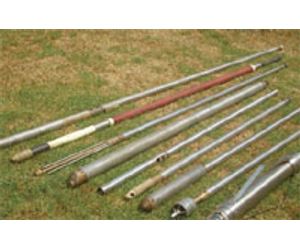
Borehole Geophysical Tools and Rough Description of their Parameters
Electric (ELXG) Sonde
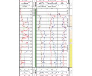
Natural Gamma Ray Log
This tool measures the natural radiation emitted by various strata. Because the most common radioelement is potassium-40, natural gamma log is usually a clay indicator. Clean sandstone or limestone, free from argillaceous materials are excursions to the left while rich clay and shale formations are excursions to the right.
Self Potential Log (SP)
This records small, naturally occurring voltages in the drill hole and is related to water quality and permeable zones in the stratigraphic sequence.
Long (64”) and Short (16”) Resistivity Logbr /> The most important use of this log is the determination of water-bearing zones taking into account the borehole characteristics, drilling mud, formation lithology and degree of invasion.
Single Point Resistance (SPR) log
SPR logs are useful in giving straightforward interpretation on lithology with a high vertical resolution in response in the resistivity of the materials near the electrode.
Formation Density (FDGS) Sonde
This induced nuclear tool uses 3.7 GBq cesium-137 gamma-ray emitting radioactive source. The detection of back-scattered gamma ray permits the computation of formation density.
Dual-Neutron (DNNS) sonde
This tool also uses induced nuclear source (i.e. 111 GBq americium- 241-berrylium-9 neutron-emitting source. The detection of thermal neutron allows the determination of hydrogen content which would be needed in computing the porosity, saturation and water content.
Three-Arm Caliper
(3ACC) – Casing Collar Locator (CCL) sonde
Borehole diameter in inches until a maximum caving of about 60 inches is being measured in this tool. Along cased section, this tool also has the capability of measuring the magnetic susceptibility of the casing section-enabling the detection of the depth of the casing collar/couplings.
Temperature/Conductivity (TCDS) sonde
The detection of fluid temperature in (˚C) and conductivity (either in ppm of μs/cm) would be extremely useful in tracking down inflow and outflow of fluids if ever the borehole cuts across two or more water bearing formations. This sonde also allows the detection of water quality zoning without doing the more tiring water sampling procedures.
Full Waveform Sonic Cement Bond Log (CBL)
Sonde
By recording the detected auditory pulses from its transmitters, the CBL sonde can map the cement grout behind the casing; therefore it can determine the “free pipe” i.e., weakly cemented casing sections in the borehole. Changes in the variations of the received auditory pulses can as well detect the casing collars in the fluid-filled section of the borehole.
Spectral Gamma (SGAM) Sonde
This tool essentially breaks down the entire gross natural gamma into its component spectrum of potassium, thorium and uranium. This tool is very useful in determining if the high gamma zone is either due to high shale percentage or ferruginous accessory minerals. This can as well deduce the paleo-environment of the sediments among others.
High Resolution Impeller Flowmeter (HRES) Sonde
With the use of spinner blades which responds to fluid flow, the flowmeter measure rotation per minute (RPM) fluid flow. It can also record fluid flow reversals.
Borehole Videography
In some instances that a visual inspection is needed in old borehole, the video camera is used. The usual clients for video graphic operation are independent farm owners and other individuals not requiring strict geophysical data. Rehabilitation of old wells which was left vacated for a period of time due to collapsed casing, pipes falling down the borehole and surfacial debris closing borehole sections are usual borehole problems addressed in this operation. Borehole videography can also be used hand-in-hand with geophysical tools to verify the problematic depth for stronger proofs in the reports. In hydrogeological assessment of extremely high saline boreholes, broken casing which gives way to an exchange of water from one aquifer to the other.
Borehole Geophysics Training
The Well Logging Division also worked in collaboration with the Training Division of the Technology Experts Company. Some training courses depict full geophysical logging topics from the field acquisition until the data interpretation. Some clients require tailored trainings with specialization in particular fields.