
- Home
- Companies
- Advanced Geosciences Inc. (AGI)
- Software
- AGI EarthImager - Version 1D - ...
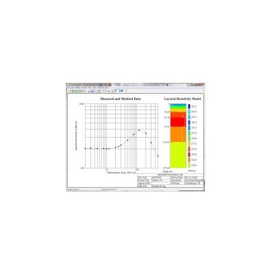
AGI EarthImager - Version 1D -Inversion Modeling Software for Vertical Electrical Sounding
EarthImager 1D is an inversion modeling software program used to interpret one-dimensional electrical resistivity data and reveal a layered model of subsurface geology. EarthImager 1D can process vertical electrical sounding (VES) data collected with Schlumberger, Wenner, dipole-dipole, pole-pole, and various other arrays. Traditionally measured and modeled geologic data is presented in basic graphed charts that are neither simple nor intuitive. With EarthImager 1D software, you can easily and quickly calculate true resistivity.
The EarthImager 1D is for use in geotechnical and geologic industries, including the following applications:
- Groundwater Exploration
- Fracture Location
- Grounding Studies
- Cathodic Protection System Design
It is also used in soil tests according to the ASTM G57 standard (the Wenner 4-pin method). Some geotechnical engineers may need to test for cathodic protection, swelling clays, or various types of soil. When the test is performed, four electrode stakes are placed at equal spacing “a”, in line around a midpoint (the survey reference point). The measurements are then taken by injecting a current into the ground through the two outer electrodes and at the same time measuring the responding voltage on the two inner electrodes. This is done for a series of pre-determined a-spacings. The larger the electrode spread, the more depth the instrument is able to sense.The recorded raw data is called apparent resistivity.
The apparent resistivity can be seen as a weighted average of the true resistivity in the different geological layers under the four electrodes. Once the survey is complete, the EarthImager 1D processes the data—typically 10-20 measurements in each location—to get the true resistivity from all the measured apparent resistivity values.
- Inversion of 1D sounding data.
- Support of Schlumberger, Wenner, dipole-dipole, and other sounding arrays.
- Reads data from the AGI Sting, MiniSting and SuperSting instruments as well as many other instrument brands.
- Automatic iterative processing.
- Forward modeling.
- Multilingual support.