

- Home
- Companies
- Alberding GmbH
- Software
- Alberding - Version AMoS - Monitoring ...
Alberding - Version AMoS -Monitoring Software
Alberding GmbH has been developing and operating monitoring systems for a wide range of applications for many years. By usingown hardware solutionscustomer specific requirementscan be considered. The use of flexible web servers (Cloud) enables afully automated data flowand alow-maintenancesystem operation.
The Alberding Monitoring Software (AMoS) is used for the continuous monitoring of objects (structures, earth`s surface). As input data, GNSS observations (RTK and Postprocessing) as well as measurement data from tachymeters, inclinometers and geotechnical sensors are supported. GNSS raw data are automatically converted into RINEX files and transferred to post-processing software. The processing results are differences in coordinates relative to a GNSS reference station or absolute coordinates (PPP processing).
The Alberding GmbH`s monitoring solutions are covering following core areas:
- Flexibly integrable and self-sufficient monitoring stations.
- Deformation monitoring.
- System status monitoring.
- Various evaluation methods (RTK, near real-time Postprocessing ...).
- Visualization via a password-protected web interface.
- Support of binary raw data of many GNSS hardware manufacturers.
- Support for standardized data formats such as RTCM, RINEX and NMEA.
- Alerting via SMS / E-mail when configurable thresholds are exceeded.
- Export of graphics and data as PDF or CSV.
- Monitoring of additional information (weather, inclination, ...)
- Interactive map with potential integration of own orthophotos.
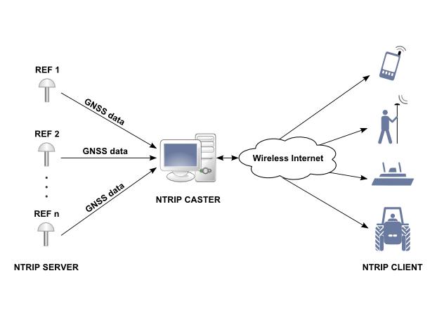
- Connection of real-time data (e.g.NMEA,RTCM,raw data) by use ofNtrip,TCP,serial
- Hourlyfile uploadusing the Alberding data format
- Central data storage by the use of theAlberding data management software
- Integration ofRTKsensors
- Increase ot the RTK accuracy byaveraging
- Data evaluation using "near-realtime" procedures bybaselineprocessing
- Storing of coordinate differences together with sensor data
- Convenient accessibilityvia web interface, usable with any browser
- Visualization / configuration viaHTTP interface
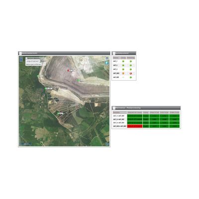
- Visualization of station positions and status on aninteractive map
- Integration of alocal map serverfor the use ofown orthophotosas map base layers
- Export functionfor easy retrieval ofCSVorPDFfiles
- Receipient individual warning settings
- Use of various types of charts such as:time series charts,vector chartsandscatter charts
- Flexible selectionof chart contents, chart types and scale ranges
- Automate reconnectionafter connection loss
- Catch upoffile transferif there had been no mobile data connection
- Continuous data flow from the sensor to the evaluated chart
- Automatic RINEX creation and baseline processing
- Warningand all-clear24 hours / 7 daysthe week
- Colored displayofsensor statesin tabular form and on a map
- Individual configurationof thresholds and time spans
- SMSand/ore-mail notificationsfor any number of recipients
- Runs onall LINUX distributions
- Convenient installationvia the Alberding software repository
- Host service of Alberding GmbH possible.
Installation, server operation and maintenance of the monitoring systems are done by the Alberding GmbH.
Usage fee for theoverall system.
- Self-developed GNSS receivers for geo-monitoring (perfectly tuned to AMoS)
- Stand-alonemode of operation andinterfacefor loggingadditional sensor data
- Support ofbinary raw data formatsof nearlyall major GNSS hardware manufacturers
- Support ofstandardized data formatslikeNMEA,RTCMandRINEX
- Flexible combination of different hardware manufacturers
- Potentialintegration of new data formats
AMoS is used in conjunction with the GNSS sensors of Alberding GmbH for automated geomonitoring. Especially the combination of AMOS with the autonomous Alberding A07 Monitoring System is interesting for numerous customers with continuous monitoring tasks due to the high degree of automation and the attractive pricing. AMoS is used in conjunction with the GNSS sensors of Alberding GmbH for automated geomonitoring. Especially the combination of AMOS with the autonomous Alberding A07 Monitoring System is interesting for numerous customers with continuous monitoring tasks due to the high degree of automation and the attractive pricing.
Permanent monitoring of environmental parameters, such as temperature, humidity, soil moisture etc. by connecting external sensors to the GNSS system.
System status monitoring helps operators assess the actual status of complex systems, such as a regional DGNSS positioning service. In order to minimise the number and duration of outages, system downtimes and performance degradations, indicators like data availability, positioning accuracy, service continuity and integrity are continuously observed.