

- Home
- Companies
- Alberding GmbH
- Software
- Alberding - Version MaPoS - Machine ...
Alberding - Version MaPoS -Machine Positioning Software
The AlberdingMaPoS softwareis designed to accurately determine the position and direction (pitch, roll, yaw) of large surface mining equipment. The machine positioning is based on the measurement data from precise GNSS RTK sensors and inclinometers. Customized formats are output to the machine`s control unit. The MaPoS software has been successfully used for more than 10 years to determine the bucket wheel center of open pit excavators using three GNSS RTK sensors or one RTK and one RTK/Heading sensor. The combination of an RTK/Heading sensor with a two-axis inclination sensor is also supported.
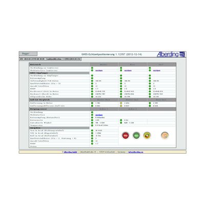
MaPoS has a web interface for position and direction monitoring. All important system parameters (e.g. receiver status, number of satellites, position quality, heading angle) are automatically monitored. If one of these parameters exceeds a predefined threshold value, visual warnings are generated.
Alberding MaPoS software supports a wide range of GNSS receiver types, real-time data formats and interfaces. Special adaptations and extensions of the software to customer requirements are possible.
Some selected features:
- Multi-antenna GNSS machine positioning system.
- Precise position and direction determination in real time.
- Modular architecture – customisable setup.
- Status monitoring via web interface.
- Automatic warnings.
- Support of numerous data formats.
MaPoS has been successfully used for more than 10 years in the combination of GNSS-RTK and inclination sensors for position and direction determination on large open pit mining equipment (bucket wheel excavators, spreaders) and the positioning of track-laying machines.
MaPoS can be easily adapted for the positioning of other moving platforms (ships, tractors, construction machinery).
- Centralised system performance monitoring.
- Real-time monitoring of reference station and satellite specific parameters.
- Real-time monitoring of broadcast signal quality.
- Automatic alert mechanism.
- System configuration through the web based graphical user interface.
- Export performance reports in PDF format.
- User configurable e-mail or SMS alerts.