

- Home
- Companies
- ARIA Technologies
- Software
- ARIA - Version Industry - Software ...
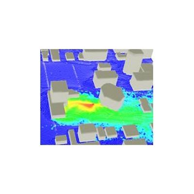
ARIA - Version Industry -Software Package
ARIA Industry is a software package that enables industries to know the impact of their plant on air quality in the surrounding area, through the simulation of actual or virtual emission scenarios. It simulates the 3D atmospheric dispersion of pollutants (gaseous or particulate) from stacks and diffusers or fugitive sources by taking into account detailed data on topography, the effect of buildings on the flow, as well as different types of simultaneous meteorological data (both ground level and upper air, measured or forecast). Used by industries, consulting companies and air quality management boards overseeing industrial areas, ARIA Industry is a software for detailed evaluation of chronic risks, equipped with a state of the art 3D Lagrangian model. When used as the computational engine of the ARIA View system, with an on-line connection to monitored stack emissions and meteorological data, it provides maps of the real time impact of an industrial site.
Modelling air pollution at industrial sites
Monitoring industrial sites in real time,
Simulation of industrial emission dispersion for specific meteorological conditions and time series,
Assessment of statistical impact industrial emissions in complex terrain (annual average, percentile),
Conducting studies (diagnostics, preparation and supervision) for air quality improvement campaigns,
Planning and development of pollution control strategies,
Calculating emissions and preparing atmospheric pollutant emission maps for a street, a city or a region,
Simulating atmospheric dispersions of all pollutants measured by air quality monitoring networks in the area under study,
Determining the contribution of each emission source,
Analyzing existing regulation strategies.
- Brings together all atmospheric pollution data in a single software system: geographical and meteorological, emissions as well as atmospheric pollutant concentration measured by sensors,
- Facilitates the management of concentration data and meteorological data available for a given area, graphical arrangement of this data, the results of models and statistical analyses performed, the display and animation of this data on selected backgrounds,
- Offers a dynamic system capable of taking into account changes in emissions by enabling a user to check all the data and the parameters pertaining to emissions at an industrial site by integrating a complete and detailed description of the different emission sources, point, line or surface situated in the area or in its proximity,
- Establishes 2D or 3D emission scenarios for the study of significant episodes,
- Simulates the meteorological conditions in 3D environment to study the past episodes or to forecast the future episodes,
- Offers an option for creating simulations on a configurable time interval (between 1 month and several years).