

- Home
- Companies
- Cityworks/Azteca Systems, Inc.
- Software
- Asset Management Software
Asset Management Software
Each municipality, public works, and utility has the responsibility to provide sustainable services to their citizens while maintaining their assets in a cost effective manner. Organizations currently using Cityworks and Esri ArcGIS are well on the way to developing an effective Enterprise Asset Management (EAM) program. Cityworks delivers a sensible and cost-effective GIS-centric Asset Management Solution (AMS) useful as a critical part of the overall EAM plan. Cityworks provides a complete foundation for a truly effective EAM program that will improve asset utilization, extending asset life and performance while reducing capital costs and asset-related operating costs.
Asset management programs can be defined as managing infrastructure capital assets to minimize the total cost of owning, operating, and maintaining assets at acceptable levels of service. Enterprise Asset Management encompasses the entire organization and recognizes the interdependencies of maintenance, operations, asset performance, personnel productivity, life cycle costs, and capital planning. The first step in any EAM plan is for an organization to conduct a needs assessment to understand what is needed to accomplish their asset management goals. In the past, many organizations managed their activities by capital and operating expenditures found in their accounting systems. However, municipalities, public works, and utilities are a capital “asset” intensive business, so they are “asset-centric” by definition because assets are central to their business purpose. One of the first tasks for any EAM plan is an inventory of existing assets with the creation of an asset registry and a commitment to maintain that asset registry. The asset registry is core to any EAM plan or strategy.
Because assets occupy a location, maps have always been a desirable method to catalog an organization’s assets. As every organization knows, assets are interconnected and in proximity with other assets and features, even if the location is not fixed. Modern “mapping systems” like ArcGIS are able to provide far more than graphical representations of data. The ArcGIS geodatabase is a database system with all the typical data assessment tools to categorize, classify, diagram, index, order, schematize, sort, and tabulate. In addition, it can render data as maps, analyze interconnectivity, proximity, and other complex spatial relationships; and model the physical world. The geodatabase as an advanced database structure is inherently location-aware, providing far more power for managing assets than traditional non-location-aware database systems, including the ability for three-dimensional modeling. This is obvious for dispersed and networked assets (roads, signs, trees, water and wastewater networks, etc.), but many Cityworks clients are discovering that concentrated assets (treatment plants, pumps, buildings, etc.) equally benefit from the power of the geodatabase, including three-dimensional facilities modeling. The ability to build an asset registry based on feature locations with multiple levels of related objects assures all of an organization’s assets are maintained in one asset data management repository, easily accessible enterprise-wide.
Over time, nearly all municipalities, public works, and utilities tend to become more GIS-centric in their thinking and approach. How much GIS functionality they employ, how it evolves, and how authentically GIS-centric their organization becomes is influenced by how they view their GIS.
As organizations accept that assets are central to their business purpose, realize the importance of knowing location, and recognize ArcGIS as a superior tool for creating an inventory of assets, they readily view ArcGIS as more than a mapping system. They recognize the powerful geodatabase is the best and only needed asset data management repository, and they recognize the benefits ArcGIS provides to optimize their maintenance and operations. The ArcGIS advanced data structure and analytical functionality proves critical for asset management and other needs. Their goal is to move more and more from short-term reactive work to longer-term life-cycle asset management. The logical and cost-effective conclusion is to use the geodatabase as the asset data management repository and to leverage their investment in GIS for asset management. ArcGIS becomes a mission critical and authoritative system and the organization becomes GIS-centric.
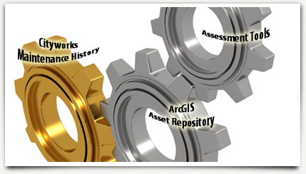
Because water, wastewater, solid waste, and storm drain utilities are some of the most capital-intensive assets to manage, the EPA, AWWA, and WEF have advocated the need to implement an effective EAM plan. An asset management system includes two critical components: 1) a Computerized Maintenance Management System (CMMS) focused on maintenance and rehabilitation work orders, and 2) inspection and monitoring of assets with regular periodic condition assessments of selected assets. The asset management focus is to maintain a desired level of service at the lowest life cycle cost. Cityworks as the proven and genuine GIS-centric CMMS (validated by the Esri Platinum Tier Partnership designation and the National Association of GIS-Centric Solutions certification) combined with the power of ArcGIS (asset data management repository) form the foundational core for a GIS-centric AMS, from which to perform intelligent and cost-effective asset management.
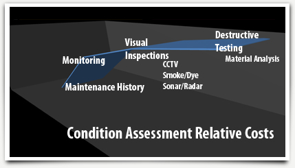
Organizations can use maintenance history assessment, visual inspection, monitoring, and condition assessment to determine and gain insights regarding the level of asset deterioration to assess likelihood of asset failure. Generally, the cost to assess likelihood of asset failure increases from CMMS maintenance history inspection (clustering, frequency, and costs analysis of unplanned maintenance) and visual inspection (routine maintenance, SCADA interface, etc.), to non-destructive and destructive condition assessment.
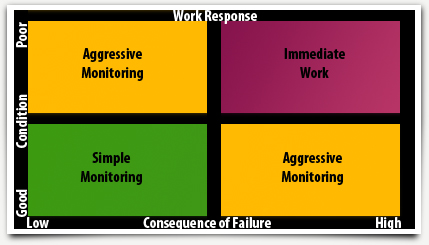
The consequence of asset failure (or criticality) can be determined using subjective-based criteria such as usage (e.g., hospital) or determined by using GIS and other analytical tools (e.g., a water main servicing a large area without redundancy or located under major transportation routes) to rate the overall impact of the failure based on the impacts to local government, customers, and the community.
GIS-centric AMS is a cost-effective approach that helps decision makers balance risk and cost. Risk takes into consideration the likelihood and consequence of the asset failing. In fact, many assets are low-risk assets. Cityworks GIScentric AMS provides out-of-the-box inspection and monitoring tools (e.g., maintenance history and routine inspections) that are appropriate to assess likelihood of failure for many assets. Non-destructive testing and destructive testing can be expensive when used on a large number of assets, but can be very effective when focused on prioritized high-risk assets, where the consequence and/or likelihood of failure are high. Cityworks GIS-centric AMS provides out-of-the-box condition assessment tools and interfaces to many third-party condition assessment tools, including age-based assessment tools, useful for accomplishing all of the goals of an EAM plan.
Some organizations may be tempted to take an “easy button” approach to asset management and rely heavily on simple age-based condition assessment, from which an asset replacement program and cost projections are derived. Condition assessment based solely on age provides the “scary number,” which can be useful to build support for an overall EAM plan but if funded could require unacceptable increases in taxes and users’ rates. The “scary number” should never be funded. Age-based condition assessment can be used along with other tools in an overall EAM plan or strategy. However, when used solely as the basis for an asset management plan, age-based condition assessment assumptions can result in misleading EAM projections to replace many perfectly good assets that have useful remaining life, thereby overstating operating and capital cost used for financial planning and budgeting.
Cityworks GIS-centric AMS provides the foundation of a sensible and cost effective condition assessment approach. Robust asset maintenance history built over time and stored in Cityworks provides a predictive standard for when similar assets may fail and how assets typically fare in the given region, climate, and other important local factors. For many assets, the clustering, frequency, and costs of unplanned maintenance activities alone – analyzed and visualized using ArcGIS tools – provide enough evidence to make an intelligent investment decision of when, where, and how maintenance and rehabilitation should take place. Often, unique attributes (or characteristics) of the asset stored in the geodatabase (such as type and the contractor) contribute more insight than age or expected life as to likelihood of failure. For high-risk assets, maintenance history and ArcGIS analytical tools can provide insight and prioritization for where to utilize limited budgets for increased inspection, monitoring, and condition assessment.
Municipalities, public works, and utilities need to set a clear vision, decide what is central to their purpose, and invest wisely as they develop an Enterprise Asset Management plan. While considering their asset management goals, organizations need to consider the importance of asset maintenance history and an asset data management repository. Cityworks is robust, mature, solid, and proven, and has always been coupled with Esri’s ArcGIS. Since the beginning, Cityworks pioneered the GIS-centric approach to managing an organization’s assets and is a staunch advocate of the benefits of an organization being GIS-centric. The reliable and enduring GIS-centric approach enables better cost reduction decision making for short- and long-term capital planning and resource allocation. To support meeting these challenging issues, Cityworks GIS-centric Asset Management Solution will be there (with ArcGIS) as a proven and critical component of the overall sensible and cost-effective Enterprise Asset Management plan.