

- Home
- Companies
- Bentley Systems, Incorporated
- Software
- Bentley Descartes - Advanced Processing ...
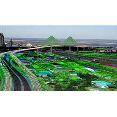
Bentley Descartes - Advanced Processing for 3D Imagery Software
Make the most of your reality modeling data with the ability to integrate point clouds, reality meshes, scalable digital terrain models, and raster imagery into your infrastructure workflows.
- Visualize and manipulate its display
- Combine it with CAD, BIM, and GIS data
- Extract information like terrain models
- Edit and clean up reality modeling data
You benefit from the ability to:
- Work with all data types, regardless of size, in a single product
- Use advanced modeling, clipping, and sectioning tools to create 3D models of as-built conditions
- Extract ground and breaklines from reality meshes and point clouds
- Search and visualize reality meshes by enriching and classifying regions with additional information
- Streamline point cloud to geometry conversion
- Enrich, segment, and classify point clouds and combine them with engineering models
- Produce animations and renderings for presentations
Convert raster documents to vector drawings
Preserve and exploit your scanned documents and drawings. Work in hybrid workflows using raster and vector editing, cleanup, and processing tools to vectorize legacy documents.
Create animations, videos, and fly-throughs
Produce high-resolution orthographic and perspective images by rendering snapshots of any size. Set image size and scales using output rulers, scale, and positioning for accurate reuse. Take advantage of the intuitive time-based fly-through and object animation system for quick and easy movie production.
Create high-fidelity images
Use high-fidelity imaging tools to support precision mapping and engineering. Combine imagery in virtually any format and projection.
Create scalable terrain models
Use and display very large terrain models to increase return on investment on large datasets. Display scalable terrain models in a variety of modes, such as smooth shading with shadows, aspect angle, elevation, slope, contours, and more. Synchronize terrain models with source data such as DGN files, point-cloud data, and more.
Integrate data from many sources with reality meshes
Enrich reality meshes with additional data like geospatial information, by attaching it to specific parts of the mesh, providing the ability to subsequently search and visualize regions of a mesh based on the associated data.
Model geometry from reality modeling data
Extract break lines, paint lines, surfaces, planes, cylinder, and cylinder center lines from reality meshes and point clouds. Efficiently clip and section point cloud and reality meshes to streamline vector extraction.
Process raster images
Use raster processing to add visualization and context to your infrastructure projects. Take advantage of immediate editing of raster data to improve the quality of your project deliverables. Lower costs associated with data maintenance by readily using legacy raster drawings in your workflow.
Visualize, manipulate and edit reality modeling data
Visualize and edit point clouds with billions of points, changing their classification, color and removing or editing points. Manipulate reality meshes and scalable terrain models with hundreds of millions of triangles. Import, retouch, and export meshes in many formats.