

- Asset Performance Software
- Piping and Vessel Design Software for Nuclear Plants
- Green Building Design Software
- Svoffice 2009
- AutoPLANT - 3D Plant Design and Modeling Software
- Nuclear Plant Design and Modeling Software
- Communications GIS and Network Engineering Software
- Environmental Regulations Software
- ConstructSim - Advanced Work Packaging and Systems Completion Software
- ContextCapture - Reality Modeling Software
- Descartes
- gINT - Geotechnical and Geoenvironmental Software
- Hevacomp - Building Energy Analysis Software
- iTwin Services Subscription
- LARS - Bridge Load Rating Modeling and Analysis Software
- LEAP - Concrete and Steel Bridge Design and Analysis Software
- LEGION - Simulation and Modeling Software
- LumenRT - Visualization and Reality Modeling Software
- Maxsurf - Maximize Vessel Performance
- MicroStation - Modeling, Documentation, and Visualization Software
- MineCycle - Mine Design and Mine Planning Software
- Moses - Integrated Offshore Simulation Software
- Navigator - BIM Review and Issue Resolution Software
- OpenBridge - Design, Modeling, and Analysis Software for Bridges
- OpenBuildings - Building Design and Energy Analysis Software
- OpenCities Map - Engineering-quality GIS and Mapping Software
- OpenCities Planner - City-Scale Digital Twin Planning and Visualization Software
- OpenFlows - Hydraulics and Hydrology Software
- OpenPlant - Interoperable 2D and 3D Plant Design Software
- OpenRail - Civil Design Software for Rail Networks
- OpenRoads - Civil Design Software for Road Networks
- OpenSite - Civil Site Design Software
- OpenUtilities - Utilities Network Design and GIS Software
- PlantSight
- PlantWise - 3D Process Plant Design Software
- PLAXIS - Geotechnical Finite Element Analysis Software
- Pointools - Point-Cloud Processing Software
- ProcureWare - Efficient and Transparent Sourcing Solution
- ProjectWise - Digital Environment
- Promis.e - Electrical and Control System Design Software
- ProStructures - Steel and Concrete Design Software
- RAM - Structural Design Software for Buildings
- RM - Bridge Design, Analysis, and Construction Software
- SACS - Offshore Structural Analysis and Design Software
- SoilVision - Geotechnical Software
- STAAD - 3D Structural Analysis and Design Software
- Superload - Automated Vehicle Permitting and Routing Software
Bentley Systems, Incorporated software
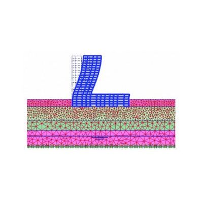
PLAXIS - 2 D Geotechnical Engineering Tool
PLAXIS 2D is a powerful and user friendly finite element package intended for two-dimensional analysis of deformation and stability in geotechnical engineering and rock mechanics. PLAXIS is used worldwide by top engineering companies and institutions in the civil and geotechnical engineering industry. Applications range from excavations, embankment and foundations to tunnelling, mining and reservoir geomechanics.

PLAXIS - 2 D Groundwater Flow Analysis Software
2D PlaxFlow is an add-on module to PLAXIS 2D. Groundwater flow is an important issue in many engineering fields such as geotechnical, environmental and hydrological engineering. In order to take groundwater flow into account in geotechnical software applications, advanced models for the simulation of the unsaturated, time-dependent and anisotropic behaviour of soil are required.
PLAXIS - 2D Dynamic Loading Modelling Software
2D Dynamics is an add-on module to PLAXIS 2D. Soil and structures are often not only subjected to static loads due to construction in and on the ground surface but also to dynamic loads. When loads are powerful, like for example earthquakes, they may cause severe damages. Vibrations may occur either man-made or natural. The source of natural vibrations in the subsoil is earthquakes. With the Dynamics module PLAXIS can analyse the effects of vibrations in the soil.
PLAXIS - 2D Thermal and Geotechnical Modelling Software
2D Thermal is an add-on module to PLAXIS 2D. The thermal module is necessary when the effects of heat flow on the hydraulic and the mechanical behaviour of soils and structures need to be taken into account in geotechnical designs with PLAXIS. For full thermal-hydro-mechanical coupling the PlaxFlow module is required as well.
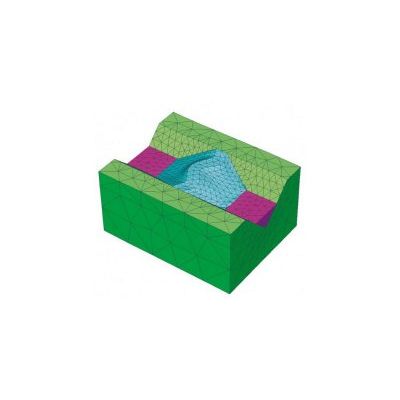
PLAXIS - 2D Geotechnical Analysis Suite
PLAXIS 2D Suite, including the Dynamics, PlaxFlow and Thermal module is a powerful and user-friendly finite element package intended for two-dimensional analysis of deformation and stability in geotechnical engineering and rock mechanics. PLAXIS is used worldwide by top engineering companies and institutions in the civil and geotechnical engineering industry. Applications range from excavations, embankment and foundations to tunnelling, mining and reservoir geomechanics.
Asset Performance Software

AssetWise - Model ALIM - Asset Lifecycle Information Management Software
AssetWise ALIM improves overall accessibility, quality, integrity, and relevance of asset data, in-context, across the asset lifecycle. Trust AssetWise ALIM as your system of record to control structured and unstructured information, control documents and records, manage changes, and ensure the delivery of accurate information to engineering, operations, and maintenance. Inherently spatial and network aware, AssetWise leverages digital engineering models to support superior asset performance.
AssetWise - Asset Maintenance Management Software
Ensure your assets are safe, reliable, and efficient over their operating life. AssetWise Asset Reliability enables you to develop proactive strategies that improve long-term asset reliability and performance. Optimize processes for the day-to-day operations of assets to minimize operational costs and maximize your production capabilities. With risk-based inspections, maintenance task analysis, and reliability-centered maintenance analysis, you can develop high-quality reliability strategies and programs that ensure your assets and asset investments deliver optimal value, maximize safety, and enhance regulatory compliance.

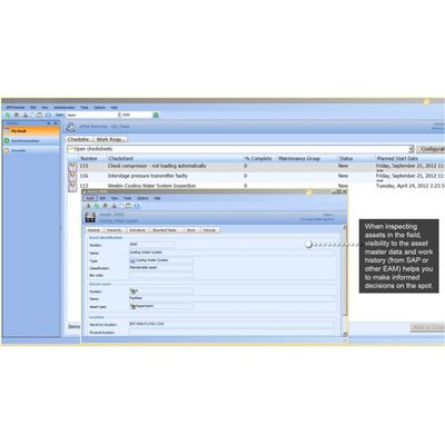
AssetWise - IIoT Data Analytics Software
The world around you is going digital. With advances in sensor technology and the explosion of the Industrial Internet of Things (IIoT), data have the potential to be your most valuable assets – providing you with actionable insights and full visibility of data to make smarter decisions. Get started today using Bentley’s specialized applications to help you gather insights, make better decisions, and create your own operational and analytical dashboards. These dashboards are made with our flexible and easy to use capabilities, which can then be shared and accessed from any web browser.
AssetWise - Enterprise Interoperability Software
AssetWise leverages your connected data environment (CDE) for operations. AssetWise Enterprise Interoperability helps extend the CDE to your entire enterprise by enabling access to multiple data sources and third party systems to deliver a common view of asset information. With AssetWise Enterprise Interoperability, information is managed where appropriate, but made available as required in disparate operations, maintenance, and engineering systems.
Piping and Vessel Design Software for Nuclear Plants

AutoPIPE - Pipe Stress Analysis Software for Oil and Gas Pipelines
AutoPIPE provides you with a comprehensive and advanced software tool specialized in pipe stress analysis. Increase your productivity and improve quality control with an intuitive modeling environment and advanced analysis capabilities. Ensure efficient workflows between pipe stress engineers, structural engineers, and CAD designers through interoperability with leading plant design applications. Speed the design of Class 1, 2, and 3 nuclear piping systems with advanced analysis capabilities such as nonlinear hydrotest analysis, integrated through-wall thermal gradient, built-in fluid transient analysis, thermal bowing or stratification, and seismic response spectra enveloping, for process, power, oil and gas, nuclear, underground, offshore, and subsea pipeline.