

Advanced Designs Corporation (ADC)
- Home
- Companies
- Advanced Designs Corporation (ADC)
- Software
- DOPRAD - Street-Level Mapping Software
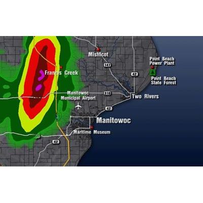
DOPRAD - Street-Level Mapping Software
Street-Level Mapping helps identify severe weather radar as it approaches specific locations such as schools, parks, airports, hospitals, or other locations of interest.
Most popular related searches
- The Street-Level Mapping feature helps allow you to create nice-looking Custom Maps of your surrounding areas.
- If you do not have the time to make nice-looking Custom Maps, you can use the Fast-Map feature. This allows you to create a map quickly and effortlessly so that you may use it immediately on-air.
- Both the Custom and Fast-Map features can draw maps as small as 1 nautical mile in size.
- Also included is the Home-In feature that allows you to zoom-in closer once you have used a Custom Street-Level Map or created a Fast-Map.
- Now you will have the competitive edge you need to keep your viewers better informed.