Eye4Software - Version Hydromagic - Single Beam Hydrographic Survey Software
Eye4Software Hydromagic is a single beam hydrographic survey software package for smaller dredging companies. Using a DGPS and echosounder it is possible to perform hydrographic surveys on job sites to check for instance the progress of the dredging process. When the survey process has been finished, the data can be edited, corrected and processed to regular spaced data points, which allow you to create a coloured depth map and / or depth contours. By comparing two soundings, you can create a report on the amount of volume dredged or moved.
Details
Eye4Software Hydromagic is a professional hydrographic survey package, which can be used to map depth areas using an echosounder. The software is very affordable and the learning curve is very short. You can start creating your first sounding within a single day !
Use the software to import, export, download, view and edit maps, display your position, calculate volumes and to record soundings. The software will work with almost any GPS/RTK receiver and echosounder, and can be used on any desktop, laptop or netbook computer running MS Windows.
Some application examples:
- Record depth data using a GPS or RTK receiver and echosounder;
- Show your current position and depth as overlay on a (hydrographic) map;
- Determine tide levels in real time by using a RTK receiver;
- Convert your soundings to a regularly spaced XYZ data (DTM);
- Convert your raw or corrected soundings to different file formats;
- Calculate volumes of basins, ponds or river sections;
- Design and generate theoretical DTM's (channel design);
- Create depth contours and save them as vector files;
- Add comments, photos, symbols or routes to your (hydrographic) maps;
- Perform realtime positioning on research and hydrographic survey vessels;
- Fishing industry, for instance to navigate inside the assigned fishing parcels;
- Export XYZ files generated from your soundings for further processing.
Hydromagic Features:
Support for GPS or RTK receivers
The software can communicate with almost any GPS or RTK receiver to retrieve your current position and show it on one of the supported raster or vectormaps. When a RTK receiver with an active correction signal is used, the software will be able to calculate the current tide level in real time.
Support for echosounders
Hydromagic offers support for a wide range of both cheap echosounder or fishfinders, or professional (dual frequency) hydrographic echosounders. The software supports standard NMEA0183 as well as proprietary echosounder formats (Odom, ODEC, PMC, DESO, etc) by the use of device drivers or plugins.
Support for other sensors
Besides GPS and echosounder, also other hardware, such as a tide receiver, magnetometer, motion or tilt sensor, heading sensor (compass) or an AIS receiver can be connected. for a full list of supported echosounders and other hardware click here.
When the required hardware is not listed, please contact support. Because the use of plugins, we can also extend the software for the use of other hardware, for instance hardware required to measure the position of dredging equipment, magnetometers or more.
Geodesy
To display a part of the globe on a display, a map projection is needed to prevent distortion of the map data. The software is shipped with a database containing over 5000 predefined local and global map datums and grids. You can also delete, modify and add new definitions in case the map grid or map datum you are using is not in the database.
The software is also able to handle correction grid files such as NTv2, NADCON and HARN/HPGN for local horizontal datums, as well as VERTCON and geoid models for local vertical datums.
Import and Export formats
Overlay data, such as comments, waypoints, matrix and sounding data can be imported from or exported to different file formats. File formats supported include ASCII XYZ, ESRI Shape, Google Earth KML/KMZ, ARC/INFO ASCII, Microstation DGN and AutoCAD DXF Files.
Tools
Some other tools and features the software offers:
- Built in sounding editor to edit, shift, filter or correct your soundings;
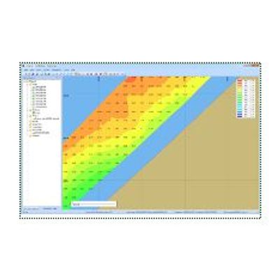
- Generate one or more depth contours as map overlay;
- Generate regularly spaced XYZ data using triangulation and interpolation (TIN);
- Create and show channel cross-sections (channel design);
- Filter incoming data from GPS receiver, RTK receiver, echosounder and other sensors;
- Calculate volumes using DTM's (Digital Terrain Models) or cross sections;
- Automatic or manual tide correction;
- Perform sound velocity and draft corrections on soundings;
- Built in map downloading tool; Download maps for the survey area from Google Earth, Bing Maps or OpenStreetMaps;
- Map calibration, to use your own downloaded or scanned GIF, PNG, BMP, JPG and TIF maps;
- Dataview to display all incoming information retrieved from GPS, echosounder and other sensors;
- Area, distance and bearing calculations;
- Display your vessel's position on the map in realtime;
- Display locations of other vessels around you using an AIS receiver;
- Use dynamic or static offsets for depth and position;
- Export sounding or DTM data to CAD, Google Earth, Grid/Elevation file, ASCII file or printer;
- Shoreline editor; Manually enter soundings or levels for places you cannot access with a boat;
Customer reviews
No reviews were found for Eye4Software - Version Hydromagic - Single Beam Hydrographic Survey Software. Be the first to review!