

Laser Technology Inc (LTI)
- Home
- Companies
- Laser Technology Inc (LTI)
- Software
- LaserSoft® MapSmart® - Field Data ...

LaserSoft® MapSmart® - Field Data Collection App
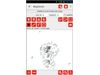
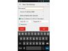
The MapSmart smartphone software for Android™ and iPadOS collects reliable, professional field site mapping data, and calculates stockpile volumes. An intuitive interface harnesses the power of sophisticated mathematics and lidar technology for your mapping project. Choose to include GPS/GNSS position data in your survey to capture the origin and reference coordinates. Offset positioning measurements output in latitude, longitude and altitude. Add the software to your toolkit to simplify your next project in mining, pole audit, forestry, infrastructure, site inspection, inventory, and more. *iPadOS version currently offers full functionality with TruPulse 200x rangeifnders and MapStar TruAngle encoders onlyMost popular related searches
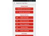
- Bring Your Own Device
- Store Heights and More
- Integrate with GPS/GNSS internal/external receivers
- Map Point, Line, Curve, and Area Features
- Stockpile Volumes and Tonnage Data
- Import Field Data Into Maps
- Operating SystemsAndroid: Check Google Play for latest compatibility
- Compatible LasersAll TruPulse® lasers with Bluetooth communication and MapStar® TruAngle®*
- Supported LanguagesEnglish, French, Indonesian, and simple Chinese (a template is available for translation)
*Only TruPulse 360°, 360°R, and 200 Bluetooth-enabled lasers displaying the menu option “BT_Enc” in the heads-up display are compatible for use with a TruAngle®. Older models of these lasers may not display this option and are not compatible for use with a TruAngle.*