

Civica Infrastructure Inc.
- Home
- Companies
- Civica Infrastructure Inc.
- Software
- Flood Forecasting Module
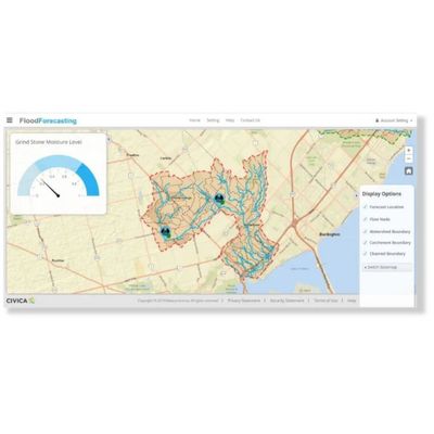
Flood Forecasting Module
Flooding potential is a function of climate and watershed conditions. Civica’s Flood Forecasting system uses spatial-enabled climate forecasts plus current, field-verified antecedent moisture conditions and other watershed data (hydraulics and vulnerable site characteristics) to issue real-time notices and warnings to the municipal managers responsible for responding to flood vulnerable sites. In an era of climate change and extreme weather events, Civica partners with municipal and rural watershed managers, through constant updates and access via mobile devices, to stay ahead of developing flood risks
Most popular related searches
flood forecasting
hydrological monitoring system
hydrological modeling
flood forecasting system
water level forecasting
climate modeling
watershed data
alarm reporting
flood risk
watershed management
- SIMPLE, SECURE, POWERFUL, & SELF-LEARNING: Combines global climate models and radar, with real measured data and calibrated industry-standard hydrologic models. It uses past data to correct future forecast and provide confidence intervals;
- WEB-BASED & MOBILE APPS: Accessible 24/7 from any laptop, computer or mobile device;
- LINKS TO EXISTING WATERSHED INFORMATION: Including digital maps, monitored data, structures, vulnerable population, and at risk assets;
- RECOGNIZED GLOBAL & REGIONAL FORECAST MODELS: Link directly to calibrated hydrologic models to output accurate predictions {GEM-LAM, NAM, HRRR, RAP);
- INDUSTRY STANDARD HYDROLOGIC MODELS: Integrates calibrated, continuously updated hydrologic models, which are the same models used for planning and operations;
- CONTINUOUS UPDATES: For current watershed conditions and predicted weather. Receive water levels, flow, potential flooding locations and extents, and planned response options;
- COMMUNICATE CURRENT AND PREDICTED INFORMATION: Uses automated
- SMS/phone/email alarms, reports, site photos and videos, and dedicated mobile application.
- Easy set up;
- Unlimited forecast locations;
- State-of-the-art climate models;
- Site-specific water level
- predictions based on hydraulic data;
- Minimized response time;
- Flexible communication channels;
- Dam operation rules included;
- Record keeping and reporting;
- Free initial consultation.