

- Home
- Companies
- Lakes Environmental Software
- Software
- Lakes Environmental - Version AERMOD ...
Lakes Environmental - Version AERMOD View 13.0 -Gaussian Plume Air Dispersion Modeling Software
AERMOD View is Lakes Environmental’s intuitive interface for the U.S. EPA’s preferred air dispersion model, AERMOD. Designed to estimate pollutant concentrations from industrial sources, AERMOD accounts for terrain, building downwash, and meteorological conditions.
See How We Compare
Discover how AERMOD View stands out from the competition with powerful features, intuitive design, and unmatched support - all in one comprehensive air dispersion modeling solution.
Feature
- AERMOD Parallel (8 Processors)
- AERMET Preprocessing Tools
- Multi-Pollutant Modeling
- Technical Support
- Regulatory Updates
AERMOD View
- Included
- Included
- Included
- Included
- Included
Competitors Software
- Add-on required
- Partial/Extra cost
- May require additional tools
- Included
- Included
Using a Different AERMOD Interface?
Are you currently using a different AERMOD interface? Make the switch to AERMOD View today and experience the difference of a complete, fully supported modeling solution with no add-ons needed!
When evaluating dispersion modeling software, cost-of-ownership matters. AERMOD View provides:
- More features upfront – no expensive modules or plug-ins to purchase
- Lower annual maintenance costs – up to $85 US less than other solutions
- Continuous updates & expert support – included with annual maintenance
With AERMOD View, you know exactly what you’re getting. No hidden fees. Just a complete, professional solution at a competitive price.
Our team of scientists, software engineers, and a Certified Consulting Meteorologist (CCM) are industry leaders in environmental modeling. We ensure AERMOD View stays aligned with the latest U.S. EPA regulatory updates and best practices.
- Continuous software updates included with maintenance
- Access to world-class technical support and training resources
- Used and endorsed by environmental professionals across multiple sectors
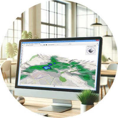
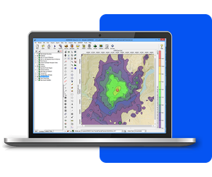
From 3D terrain visualization to building downwash and urban/rural classifications, AERMOD View provides intuitive tools that simplify your workflow—without compromising performance or compliance.
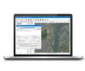
Fully integrated GIS-based interface combining easy to use graphical tools.
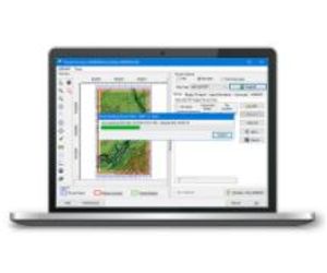
Export your buildings, sources, receptors and contours into Google Earth to share results with others.
Automatically download and import high-resolution satellite and street map imagery into your projects.
Advanced terrain processing capabilities are offered for several terrain data file formats.
AERMOD Parallel for up to 8 processors available at no additional cost.
Comprehensive 3D visualization of your entire modeling area to meet all your modeling needs.
We’re here to make things easy! Here’s a list of everything included with your software purchase:
Our products are Microsoft Windows-based programs that can be installed in the following Windows operating systems:
- 32-bit and 64-bit Operating Systems
- Windows 10 or 11
Minimum Requirements:
- An Intel Pentium 4 processor (or equivalent) or higher
- At least 2 GB of available hard disk space
- 1 GB of RAM (2 GB recommended)
AERMOD View is an interface for the AERMOD, ISCST3, and ISC-PRIME US EPA air dispersion models.
- Model Name: AERMOD
- Developed by: AERMIC – (American Meteorological Society (AMS) and United States Environmental Protection Agency (US EPA)
- Model Type: Steady-state Gaussian plume air dispersion model
- Range: Up to 50km from the source
- Atmospheric Stability Model: Planetary boundary layer theory, turbulence scaling concepts
- Windfield: Homogeneous
- Release Types: Buoyant or neutrally buoyant plumes
- Emission Types: Constant or time-varying, planned or fugitive
- Atmospheric Chemistry: NOX to NO2 and SO2 decay
- Source Types: Point, area, volume, open pit, line*, flare*
- Meteorology: Hourly surface and upper air data (processed by AERMET)
- Terrain: Flat or elevated (terrain processed by AERMAP)
- Receptors: Several types of grids (Cartesian, polar) and discrete receptors
- Other Options: Building downwash (modeled by BPIP-PRIME)
- Regulatory Status: Preferred US EPA regulatory model for near-field applications