
Geo2X - Gravity Exploration Software
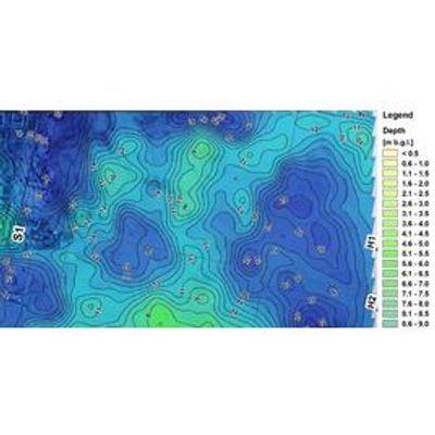
Gravity exploration methods study the spatial variation of the gravity field. The variations can depend on the heterogeneous distribution of underlying geological units. A sharp analysis on these variations allows the reconstruction of an underground density model.
Gravity is particularly adapted to void detection due to the strong density contrast between a void and its host rock. This method grants a regionalization of singular information, such as borehole data, and limit the cost of terrain investigations.
Gravity exploration is performed as profiles or maps. Microgravity focuses on subsurface analysis where gravity highlights bigger, regional variations of the gravity field.
Data is processed through corrections for topography, moon and sun attraction, neighboring mountains and valleys, and, for urban microgravity, the effects of basements and buildings.
- Void detection
- Karst detection
- Alteration, faulting
- Buried structures
- Archaeology
- Density calculations
- Geological structures
- Deep geothermal energy
- Gravity / Microgravity
- Profiles, cartography
- Density calculations
- Geological modeling
- 2D / 3D inversion
- Advanced interpretation