
- Home
- Companies
- Geolitix Technologies Inc.
- Software
- Geolitix - Geological Mapping Software
Geolitix - Geological Mapping Software
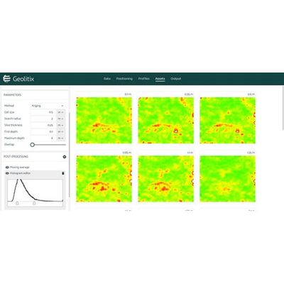
Data from low-frequency GPR systems can be interpreted in a 3D-aware environment to build exportable geological models.
Low-frequency GPR is often used for shallow geological imaging, and in mineral exploration or geotechnical investigations. Geolitix can import GPR data from all major radar manufacturers and incorporates advanced GPS filtering and editing functions to ensure your GPR profiles are perfectly positioned. Advanced processing tools, including gains, filters and complex attribute analysis allow the maximum amount of information to be interpreted on the profiles. These interpretations can be automatically gridded into 3D surfaces and exported into a variety of CAD/GIS formats, or as Google Earth files.
Geolitix allows full 3D visualization of profiles, interpreted horizons and topography.