

- Home
- Companies
- Geolitix Technologies Inc.
- Software
- Geolitix - Rebar and Bridgedecks ...
Geolitix - Rebar and Bridgedecks Software
Rebar in concrete and bridge decks is automatically detected and positioned in 3D, allowing the system to generate maps of rebar depths and corrosion conditions in Google Earth™.
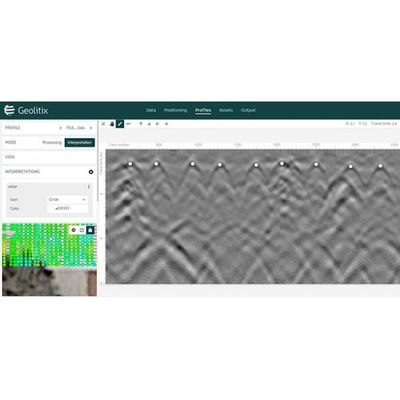
GPR is now an accepted standard for rebar imaging, both for detecting rebar and post tension wires, and for providing an indication of the health of the rebar based on the radar reflection amplitude. Geolitix imports data from the major high-frequency radar manufacturers, including Malå Geoscience, Sensors and Software, GSSI and Proseq. Rebar data are usually collected on an XY grid, and Geolitix can quickly position and geo-reference such grids. Background images of surveyed walls or surfaces can be positioned so that they act as a base map to match the radar grid. Processing functions, including time-zero corrections, gains, filters, and migrations can be performed on an entire dataset almost instantly through the power of cloud computing.
Individual rebar can be mapped in 3D, and slices can be made at any depth interval. Automated hyperbola-detection routines can be used to map the health of rebar as heat maps. Data can be exported in JPG or CSV format, individual rebar can be exported in 3D DXF format, and slices and rebar amplitude maps can be exported in a variety of CAD and GIS formats.