
- Home
- Companies
- Geolitix Technologies Inc.
- Software
- Geolitix - Utilities Mapping Software
Geolitix - Utilities Mapping Software
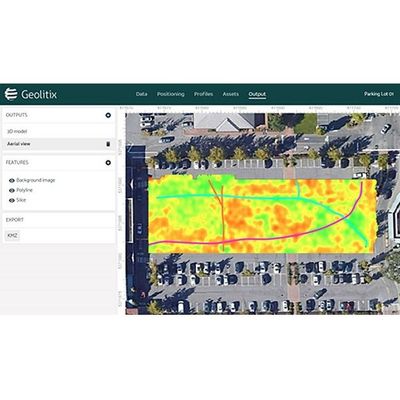
Pipes, cables and USTs are easily detected and mapped using single or multi-channel GPR data for output to AutoCAD™ or Google Earth™.
Geolitix was designed from the ground up to automate the flow of data editing, processing, interpretation and reporting for utilities mapping. Geolitix offers a drag-and-drop interface that allows you to easily transfer data from all major radar manufacturers. Geo-referencing using an arbitrary XY grid or GPS data is simple – you can easily edit the positioning information to ensure all of your data is positioned perfectly.
Processing involves time-zero correction, gains and filters, including migration and envelope functions. By exploiting the speed of clustered computing, these computations can be performed in real-time on all of the profiles in your dataset, regardless of its size. Interpretations can then be generated in a 3D-aware environment to show pipes, rebar and horizons. 3D data from large datasets can be sliced in a fraction of the time previously required using old PC-based software, allowing output of isosurfaces, slices and interpretations – all geo-referenced for easy input into your report, CAD/GIS software or Google Earth™.