


Rezatec - Geospatial AI for Ground Motion & Seepage
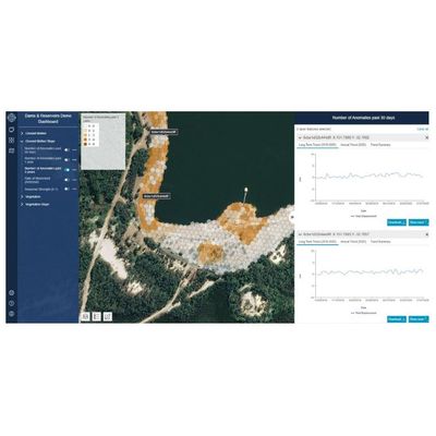
Ground Motion & Seepage is the only product of its kind that remotely provides a detailed historical and current view of structural movement for all your dams – even across inaccessible locations. Its satellite and multiple data feeds fused with advanced analytics deliver the most frequent, accurate insights on unusual changes in ground motion and vegetation change, giving you the power to see developments between routine structural surveys. Its unique historical analysis, combine with continual data refreshes to accurately highlight exact risk areas, which means you deploy your investigation and maintenance resources to the right place at the right time.
Build a full risk profile
- Unique historic & current view
- Tracks anomalous changes
- Monitors all dams
- Ideal for remote locations
Track issues between surveys
- Frequent, accurate insights
- Correlates trend data
- Alerts of unusual changes
- Millimeter accuracy
Deploy to the right place
- Define exact risk areas
- Direct investigation & maintenance teams
- Focus on maximum impact
- Data collected remotely
With changing risk metrics and an increased focus on risk management, dam owners are pushing for new approaches to understand their risks and potential liabilities. Ultimately, managing the challenges of risk invariably comes down to monitoring. For dam owners and operators, turning to emerging techniques and technologies that can supplement the standard visual inspection process has been the bulwark of dam safety since the earliest origins of the industry.
Sensors such as a piezometer, strain gauges and tilt monitors, for example, are being deployed to produce measurements at key locations of a dam structure. Certainly, these devices are accurate but typically only offer data from those single points of the structure where the devices are installed. This results in knowledge gaps in those areas between sensors and is especially significant when considering that some embankments might be several miles long. Sensors such as piezometers are also difficult to install, presenting health and safety issues. They can also fail and need to be replaced periodically.
Dam owners are instead turning to other remote monitoring tools such as drones, UAVs and satellites to conduct large-scale assessments. While drones do reduce health and safety risks associated with visually inspecting hard-to-access areas of a dam face, for instance, they also have limitations. Accuracy is perhaps the most regularly reported challenge with drone use, with operator comparisons highlighting drones pick up 20 to 30 millimeters, which is a long way off the millimetric accuracy that can be achieved with new, advanced technologies. Drones are also potentially an expensive route to remote monitoring when used more frequently than for annual inspections.
Now though, with the increasing availability of satellite and geospatial data combined with sophisticated machine-learning and AI algorithms, dam owners have new options. Advanced ground motion and seepage monitoring as part of an intelligent, digitally led approach to risk management is possible.