
Rezatec
Rezatec - Geospatial AI for Water Quality Monitoring
FromRezatec
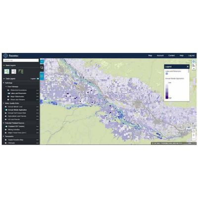
Track the effects of land use on water quality across wide watersheds. Proactively manage upstream pollution risks to reduce the requirement for costly downstream treatment. Remote. Cost-effective. Scalable. Water Quality empowers water utilities leaders to remotely monitor issues across entire water catchment areas: remotely, at scale, cost-effectively. It predicts land use change and environmental risk, and it provides sub-catchment insights into how land use impacts pollution levels. Satellite and multiple data feeds combine with advanced AI to track changing issues across watersheds. Use it to identify and dynamically manage diffuse pollution levels resulting from changing land use.