
Simutech
HISprof - Profile-Editing-Module
FromSimutech
In HIS`3D® all values are stored with coordinates - a full localization of data values! Coordinates are used in many applications: sediments, measurement in different river depths, sending hydrological values to GIS-models, etc. HISprof offers a full-featured desktop for editing and administrating profiles. HISprof deals with all kinds of profiles: length and cross profiles; river profiles, valleys or electricity line layouts.
Most popular related searches
river profiling
GIS modeling
flow velocity
sediment monitoring
vertical profiling
acoustic doppler current profiler
river flow
hydrology
hydrological monitoring system
hydrological modeling
- numerical and graphical editing of profiles
- presentation in horizontal and vertical projection
- profile points legends
- seriphs for subterranean areas
- marker symbols
- colour intensity plots (e.g. for river temperatures and flow velocities)
- printing on plotters with plot optimization
- printing to endless forms
- export into the dxf-format
- arbitrarily formatable import/export files
- creation of profiles out of a cloud along a path
- automatic linking of profiles
- epoche statistics
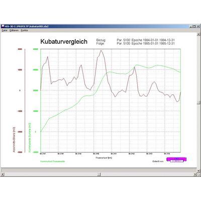
- epoche comparison
- cubature computation
- with height level borders
- in several layers
- difference curves
- point reduction
- ADCP evaluation