
- Home
- Companies
- Inertial Labs, a VIAVI Solutions ...
- Software
- Inertial Labs - Version ROCK - LiDAR ...
Inertial Labs - Version ROCK -LiDAR Point Cloud Software
Inertial Labs recommends the ROCK Cloud for all LiDAR point cloud processing. The ROCK Cloud is an entirely cloud-based software where users can upload, share, manage, and process RESEPI LiDAR data. The ROCK Cloud gives users all the tools to get a deeper analysis of their point cloud for vegetation management, hydrologic modeling, and much more. PCMaster produces LAS files in WGS 84 datum and UST projection zone, the ROCK Cloud is an excellent tool for users looking to convert LAS files in a local datum and preferred projection coordinate system.
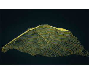
A DEM (Digital Elevation Model) and Contours provide accurate insight into the ground topography. The first step in creating these accurate deliverables is to classify the ground using the ROCK Cloud AI Engine.
Once the ground is accurately determined, a DEM and contours can be generated. Contour lines are delivered in the most popular formats so that you can import them into any CAD or GIS software package. Additionally, you can view the contours right on the ROCK Cloud!
Users can generate ground classified .laz files, SHP files containing geometry, DBF attribute format files, SHX shape index files, DEMs in TIF format, and accurate reports with the ROCK cloud.
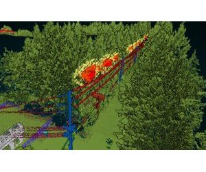
Power-line corridor management is critical to delivering safe and uninterrupted electricity. The Power-line Corridor Management deliverable gives you the intelligence needed from your LiDAR point cloud. Upload data receive a classified point cloud and shapefile of the active danger points. You can visualize that danger points right from the rock cloud!
Year after year, vegetation continues to infringe on our power grid. With drone LiDAR, you can quickly view and catalog the highest-risk areas for your power-line corridor. See all of your encroachments easily on both the map and LiDAR view!
With the ROCK Cloud, you can classify ground points, high/medium/low vegetation, buildings, substations, transmission towers, and more!
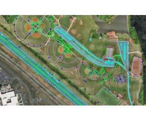
ROCK Planimetrics combines superior artificial intelligence, machine learning, and quality control to create accurate planimetric deliverables. Additionally, you can select and pay for specific areas of your dataset, so you are paying for only the acreage you need!
Select between 1″=20′, 1″=40′, or 1″=100′ to determine the level of detail you require. If the deliverable you need doesn’t fall neatly within these scales, email your requirements to planimetrics@rockrobotic.com, and they will build you a custom quote!
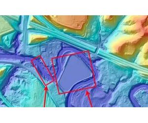
ROCK Hydrology delivers a hydro-flattened topographic DEM and contours where waterbodies have a single elevation and streams and rivers are flat bank-to-bank, with a monotonic flow. A hydro-flattened DEM is a topographic DEM and should not be confused with hydro-enforced or hydro-conditioned DEMs representing hydrologic surfaces. Hydro-flattening aims to create an artificial water surface over water bodies that will possess essential surface characteristics of natural water.
Hydro-flattened data is delivered under the following parameters defined in the USGS Lidar Base Specification Guidelines.
ROCK Hydrology delivers users with a ground classified laz file, an SHP file containing geometry data, a DBF attribute format file, an SHX shape index file, a hydro-flattened DEM in TIF format, and an accuracy report.