

- Home
- Companies
- Bluesky International Ltd.
- Software
- LiDAR - Height Data Software
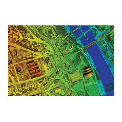
LiDAR - Height Data Software
LiDAR has become the de facto data source for those in need of detailed, accurate terrain information. A LiDAR sensor acquires the height of both the terrain, and any above ground features such as trees and buildings, to an accuracy and resolution unparalleled by other airborne methods.
Bluesky have an extensive portfolio of LiDAR data available as part of our data catalogue, ensuring that no matter your end application or area of interest, we’ll be in a unique position to meet your requirements.
Bluesky are committed to ensuring our off-the-shelf data is as current as possible, and our ongoing update programme has seen 2013 acquisition of LiDAR data for Newcastle, Birmingham, Slough, Bury and Stafford at a higher accuracy and resolution than ever before.
Alongside our own data catalogue, we are official resellers of LiDAR from a number of other sources, allowing us to provide you with a single point of contact for all your LiDAR requirements.
- Exceptionally High Accuracy of up to +/-3cm
- Surface and Terrain models
- Off-the-shelf surveys to order
- Extensive LiDAR Coverage
- Available in many formats: ASCII XYZ, ARC Grid, GeoTIFF, 3DS, MAX, Erdas Imagine
- Urban environments - 3d models & network planning
- Flood risk
- Forrestry
- Transmission lines, highways, corridor mapping
- Archaelogy
- Wind farm planning
- Coastal surveys
- Quarries