- Home
- Companies
- Guideline Geo
- Software
- MALÅ - GroundVision Software
MALÅ - GroundVision Software
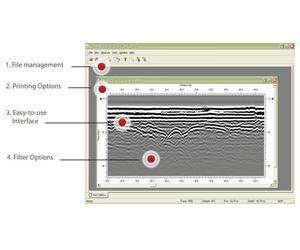
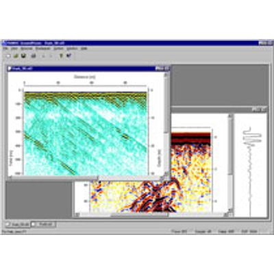
MALÅ GrondVisionTM software is a data acquisition software designed by MALÅ Geoscience dedicated to MALÅ GPR Systems in single or multi-channel mode. The software is available as MALÅ GroundVision and MALÅ GroundVision 2.
MALÅ GroundVision is the first version designed for the MALÅ RAMAC/GPR parallelport communication units; MALÅ CUII and MALÅ X3M and offers an easy-to-use interface, file management, printing and other key features such as GPS compatibility.
GroundVision 2 is the latest version optimized and designed for the new MALÅ Geoscience platform of units; MALÅ ProEx (Professional Explorer Unit) and MALÅ X3M both with Ethernet communication.
Each measurement and its associated settings are stored in files. MALÅ GroundVision and MALÅ GroundVision 2 provide the option of filtering the data during data acquisition and also afterwars during post-processing. The software supports both GPS logging and multiple markers during measurement. All radargrams can be printed as such, or post processed by further software.