

Everise Technology Ltd.
- Home
- Companies
- Everise Technology Ltd.
- Software
- Lidars - Network Observation and ...
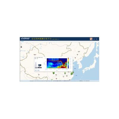
Lidars - Network Observation and Analysis Platform
LIDAR ONLINE platform, by adopting the latest hot WEBGIS RIA technology and parallel connecting aerosol monitoring lidars, targets at a comprehensive data collection and analysis, and ultimately providing data basis and technical support for environmental and meteorological early warning and forecasts.
Most popular related searches
aerosol laser LiDAR
GIS mapping
field data
LiDAR data
3D scanning
aerosol LiDAR
LiDAR network
LiDAR
aerosol monitoring
wind doppler LiDAR
- Build regional lidar network, by integrating different lidars of multiple functions (like aerosol laser lidar, laser lidar with 3D scanning function, doppler wind lidar, raman temperature lidar etc.)
- Secondary pre-processing of lidar data to form intermediary data for other platforms.
- Display images of each single-point lidar, including the current 24H data or past 24H variation trend of extinction coefficient, PBL and AOD.
- Display wind field data, combined with GIS map.
- Display temperature field data, combined with GIS map.
- Display aerosol field data, combined with GIS map, and broadcast aerosol field variation trend.
- Manage user’s permissions, roles, functions, pages, and access to lidars, reports, etc.
- Generate data and reports to be uploaded, downloaded and pushed on WeChat.
- Compatible operation of multiple platforms, various instruments and multiple view windows.
- Simple interface, easy for operation.
- The fully functional platform could integrate multiple lidar at high efficiency and generate diversified data.
- WeChat push of analysis reports.