

FarmFacts GmbH
- Home
- Companies
- FarmFacts GmbH
- Software
- Next - Version GIS Office - Subarea ...
Next - Version GIS Office -Subarea Management Software
FromFarmFacts GmbH
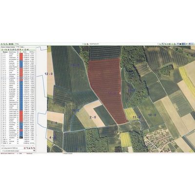
The background view shows current areal images while several map layers can be activated to show field boundaries and field groups. All this data can be directly linked to NEXT Field Card IndexOFFICE or NEXT Subarea ManagementOFFICE. You can measure areas and distances, design areas or overlap them. Several tools allow for the export (e.g. PDF) and printing of your chosen maps. Using the import and export functions you can link your NEXT GISOFFICE to many other applications. NEXT GISOFFICE For example, you can import areas from Google Earth. Using the free layer administration tool you can import all desired geodata directly to your GIS, save it and use it with all other GIS operating data.
Most popular related searches
- Measuring of areas and distances
- Area design
- Layer administration tools
- Extensive and customised analyses
- Coordinate conversions
- Import from various data sources
- Link to many other NEXT FarmingOFFICE modules