

PIX4Dcatch
Turn your mobile device into a professional 3D scanner. From underground utilities to public safety, create a model of your scanned objects for use in different industries. Underground utilities:
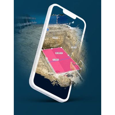
Create geolocalized open trenches models by simply walking around them. Accurately document and calculate volumes for invoicing. Construction: Quickly and accurately collect, process, and visualize as-built measurements and 3D models, even in the most demanding conditions. Surveying: Complete an entire survey in a few minutes and create a 3D point cloud, a digital surface model, and a true orthomosaic of your area. Public safety: Document and recreate crime scenes, record evidence, and provide a clear picture for investigators and forensic teams.
PIX4Dcatch is a mobile application designed for iOS and Android devices which enables you to take images of a scene, ready to be converted into a 3D model geolocated and in real time.
Utilize the power of photogrammetry technology to reconstruct reality in 3D
- Use your phone or your tablet
- Walk around your subject of interest
- Real time information and real-time 3D meshing
- Saves your current position
- Generates scaled and georeferenced 3D outputs
- A complete and accurate 3D model
- Export, process, or analyze your project
- Choose among the many Pix4D products
- PIX4Dcloud to share your project and measure volumes