
- Home
- Companies
- OceanWise Ltd.
- Software
- OceanWise - Productivity Tools - ...
OceanWise - Productivity Tools - Maritime Toolbar and Workflow Extensions Software
Powerful and easy to use tools for manipulating maritime data. Maritime Toolbar and Workflow Extensions are a suite of software tools, developed in conjunction with ports and coastal authorities that manage marine and coastal assets, streamline your workflows providing improved decision support and situational awareness in activities such as:
- Compliance and conservancy
- Maritime asset management
- Project management
- Chart production, including Electronic Navigational Charts
- Object Based Image Analysis / RSOBIA
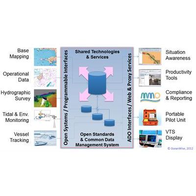
Geographic Information Systems (GIS) help you store, analyse, edit and disseminate environmental, operational, asset and other data with a spatial component. But the interface between these processes is often a source of major inefficiency and frustration, either because information is not easily accessible or it requires considerable preparation before it can be used.
Our Maritime Toolbar and Workflow Extensions provide rich functionality and complement the data management and manipulation tools inherent in GIS to address particular workflow demands within your marine and coastal operations.
The software uses the philosophy of lean process management by providing you with the tools required to manage common data as a central resource as well as streamlining the exchange of data between processes, systems and external stakeholders. It’s features include:
- allowing ready execution of common and complex everyday tasks
- simplifying batch tools which automate repetitive or large-scale data processing
- raster processing tools without need for costly GIS extensions
- easy access to location-specific data to support new insight and perspectives
The following Workflow Extensions are currently available to support common processes related to:
- Dredging and Licensing Management Extension
- Hydrographic Survey Management Extension
- Environmental Samples Management Extension
- Electronic Navigational Charts (ENC) Production
- Object Based Image Analysis Extension / RSOBIA
Each extension can be installed alone or in combination with Maritime Toolbar and GIS, depending on your requirements. Maritime Toolbar complements Cadcorp SIS, Esri ArcMap and QGIS platforms. It can be used in conjunction with file-based data, existing data storage systems, or combined with Ocean Database.